Weather Alert in Ohio
Flood Warning issued April 1 at 12:02AM EDT until April 1 at 4:00AM EDT by NWS Cleveland OH
AREAS AFFECTED: Cuyahoga, OH; Geauga, OH
DESCRIPTION: * WHAT...Flooding caused by excessive rainfall is occurring. * WHERE...A portion of northeast Ohio, including the following counties, Cuyahoga and Geauga. * WHEN...Until 400 AM EDT. * IMPACTS...Flooding of rivers, creeks, streams, and other low-lying and flood-prone locations is imminent or occurring. * ADDITIONAL DETAILS... - At midnight EDT, Doppler radar indicated heavy rain due to thunderstorms. Between 1 and 3 inches of rain have fallen. There have been reports of scattered roadway and basement flooding across the area. The threat for rapidly rising flash flooding has ended, but flooding continues to pose a hazard overnight tonight. - Additional rainfall amounts up to 0.5 inches are possible in the warned area. - Some locations that will experience flooding include... Cleveland, Chardon, Parma, Lakewood, Cleveland Heights, Strongsville, Westlake, North Royalton, North Ridgeville, Solon, Avon Lake, Warrensville Heights, Macedonia, South Russell, Middlefield, Burton, Highland Hills, Chesterland, North Olmsted and Garfield Heights. - Please visit www.weather.gov/safety/flood for flood safety and preparedness information.
INSTRUCTION: Turn around, don't drown when encountering flooded roads. Most flood deaths occur in vehicles. Be especially cautious at night when it is harder to recognize the dangers of flooding.
Want more detail? Get the Complete 7 Day and Night Detailed Forecast!
Current U.S. National Radar--Current
The Current National Weather Radar is shown below with a UTC Time (subtract 5 hours from UTC to get Eastern Time).

National Weather Forecast--Current
The Current National Weather Forecast and National Weather Map are shown below.

National Weather Forecast for Tomorrow
Tomorrow National Weather Forecast and Tomorrow National Weather Map are show below.

North America Water Vapor (Moisture)
This map shows recent moisture content over North America. Bright and colored areas show high moisture (ie, clouds); brown indicates very little moisture present; black indicates no moisture.

Weather Topic: What is Freezing Rain?
Home - Education - Precipitation - Freezing Rain
 Next Topic: Graupel
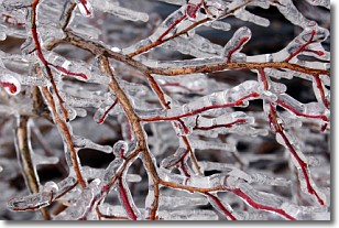
Freezing rain is a condition where precipitation which has fallen in the form of
water droplets reaches temperatures which are below freezing and freezes upon
coming into contact
with surface objects. The result of this precipitation is a glaze of ice which
can be damaging to plants and man-made structures. A severe onset of freezing
rain which results in a very thick glaze of ice is known as an ice storm.
Next Topic: Graupel
Weather Topic: What is Hail?
Home - Education - Precipitation - Hail
 Next Topic: Hole Punch Clouds
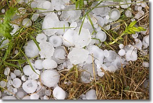
Hail is a form of precipitation which is recognized by large solid balls or
clumps of ice. Hail is created by thunderstorm clouds with strong updrafts of wind.
As the hailstones remain in the updraft, ice is deposited onto them until their
weight becomes heavy enough for them to fall to the earth's surface.
Hail storms can cause significant damage to crops, aircrafts, and man-made structures,
despite the fact that the duration is usually less than ten minutes.
Next Topic: Hole Punch Clouds
Current conditions powered by WeatherAPI.com


