Weather Alert in New York
Flood Warning issued March 31 at 10:13PM EDT until April 1 at 4:53PM EDT by NWS Buffalo NY
AREAS AFFECTED: Erie, NY
DESCRIPTION: ...The Flood Warning is extended for the following rivers in New York... Cazenovia Creek Near Cazenovia Creek at Ebenezer affecting Erie County. For the Cazenovia Creek...including Cazenovia Creek at Ebenezer... Minor flooding is forecast. * WHAT...Minor flooding is forecast. * WHERE...Cazenovia Creek near Cazenovia Creek at Ebenezer. * WHEN...Until tomorrow afternoon. * IMPACTS...At 10.0 feet, Flood stage, minor flooding can be expected in low lying areas east of Orchard Park Road and south of Ridge Road in West Seneca. Some inundation of Cazenovia Park in South Buffalo. * ADDITIONAL DETAILS... - At 10:00 PM EDT Tuesday the stage was 8.72 feet. - Bankfull stage is 10.0 feet. - Forecast...The river is expected to rise above flood stage late this evening to a crest of 11.7 feet just after midnight tonight. It will then fall below flood stage late Wednesday morning. - Flood stage is 10.0 feet. - Flood History...This crest compares to a previous crest of 11.6 feet on 03/17/2003. - http://www.weather.gov/safety/flood
INSTRUCTION: Turn around, don't drown when encountering flooded roads. Most flood deaths occur in vehicles. Caution is urged when walking near riverbanks. Be especially cautious at night when it is harder to recognize the dangers of flooding. Additional information is available at www.weather.gov. The next statement will be issued Wednesday morning by 1015 AM EDT.
Want more detail? Get the Complete 7 Day and Night Detailed Forecast!
Current U.S. National Radar--Current
The Current National Weather Radar is shown below with a UTC Time (subtract 5 hours from UTC to get Eastern Time).

National Weather Forecast--Current
The Current National Weather Forecast and National Weather Map are shown below.

National Weather Forecast for Tomorrow
Tomorrow National Weather Forecast and Tomorrow National Weather Map are show below.

North America Water Vapor (Moisture)
This map shows recent moisture content over North America. Bright and colored areas show high moisture (ie, clouds); brown indicates very little moisture present; black indicates no moisture.

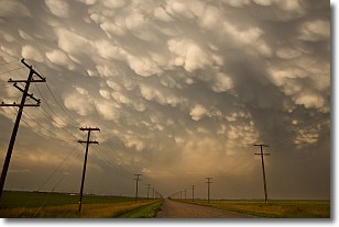
Weather Topic: What are Mammatus Clouds?
Home - Education - Cloud Types - Mammatus Clouds
 Next Topic: Nimbostratus Clouds
A mammatus cloud is a cloud with a unique feature which resembles
a web of pouches hanging along the base of the cloud.
In the United States, mammatus clouds tend to form in the warmer months, commonly
in the Midwest and eastern regions.
While they usually form at the bottom of a cumulonimbis cloud, they can also form
under altostratus, altocumulus, stratocumulus, and cirrus clouds. Mammatus clouds
warn that severe weather is close.
Next Topic: Nimbostratus Clouds
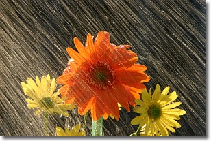
Weather Topic: What is Precipitation?
Home - Education - Precipitation - Precipitation
 Next Topic: Rain
Precipitation can refer to many different forms of water that
may fall from clouds. Precipitation occurs after a cloud has become saturated to
the point where its water particles are more dense than the air below the cloud.
In most cases, precipitation will reach the ground, but it is not uncommon for
precipitation to evaporate before it reaches the earth's surface.
When precipitation evaporates before it contacts the ground it is called Virga.
Graupel, hail, sleet, rain, drizzle, and snow are forms of precipitation, but fog
and mist are not considered precipitation because the water vapor which
constitutes them isn't dense enough to fall to the ground.
Next Topic: Rain
Current conditions powered by WeatherAPI.com


