Weather Alert in Oregon
Winter Storm Warning issued March 31 at 2:59PM PDT until April 2 at 5:00PM PDT by NWS Portland OR
AREAS AFFECTED: Cascades of Marion and Linn Counties; Cascades of Lane County
DESCRIPTION: * WHAT...Heavy snow expected. Total snow accumulations between 10 and 18 inches. Winds gusting as high as 40 mph. * WHERE...Cascades of Lane County and Cascades of Marion and Linn Counties. * WHEN...From 5 AM Wednesday to 5 PM PDT Thursday. * IMPACTS...Roads, and especially bridges and overpasses, will likely become slick and hazardous. * ADDITIONAL DETAILS...There is a 25-50% chance for snowfall rates exceeding 1 inch per hour along Santiam and Willamette Passes at any given hour, with the highest chances occurring between 11 PM Wednesday and 8 AM Thursday.
INSTRUCTION: Consider postponing travel until weather conditions improve. If you must travel, be sure to slow down and allow extra time. If your car becomes trapped in deep snow, be sure to keep your car off to stay safe from potential carbon monoxide poisoning. If you are using a generator, be sure to keep it outdoors and away from windows and vents. Be aware that walking surfaces may be slick. Walk with extra care. Backcountry recreation is not advised.
Want more detail? Get the Complete 7 Day and Night Detailed Forecast!
Current U.S. National Radar--Current
The Current National Weather Radar is shown below with a UTC Time (subtract 5 hours from UTC to get Eastern Time).

National Weather Forecast--Current
The Current National Weather Forecast and National Weather Map are shown below.

National Weather Forecast for Tomorrow
Tomorrow National Weather Forecast and Tomorrow National Weather Map are show below.

North America Water Vapor (Moisture)
This map shows recent moisture content over North America. Bright and colored areas show high moisture (ie, clouds); brown indicates very little moisture present; black indicates no moisture.

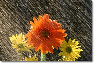
Weather Topic: What is Precipitation?
Home - Education - Precipitation - Precipitation
 Next Topic: Rain
Precipitation can refer to many different forms of water that
may fall from clouds. Precipitation occurs after a cloud has become saturated to
the point where its water particles are more dense than the air below the cloud.
In most cases, precipitation will reach the ground, but it is not uncommon for
precipitation to evaporate before it reaches the earth's surface.
When precipitation evaporates before it contacts the ground it is called Virga.
Graupel, hail, sleet, rain, drizzle, and snow are forms of precipitation, but fog
and mist are not considered precipitation because the water vapor which
constitutes them isn't dense enough to fall to the ground.
Next Topic: Rain
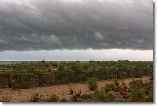
Weather Topic: What are Shelf Clouds?
Home - Education - Cloud Types - Shelf Clouds
 Next Topic: Sleet
A shelf cloud is similar to a wall cloud, but forms at the front
of a storm cloud, instead of at the rear, where wall clouds form.
A shelf cloud is caused by a series of events set into motion by the advancing
storm; first, cool air settles along the ground where precipitation has just fallen.
As the cool air is brought in, the warmer air is displaced, and rises above it,
because it is less dense. When the warmer air reaches the bottom of the storm cloud,
it begins to cool again, and the resulting condensation is a visible shelf cloud.
Next Topic: Sleet
Current conditions powered by WeatherAPI.com


