Weather Alert in Pennsylvania
Severe Thunderstorm Warning issued March 31 at 11:41PM EDT until April 1 at 12:30AM EDT by NWS Pittsburgh PA
AREAS AFFECTED: Allegheny, PA; Washington, PA; Westmoreland, PA
DESCRIPTION: SVRPBZ The National Weather Service in Pittsburgh has issued a * Severe Thunderstorm Warning for... Allegheny County in southwestern Pennsylvania... Central Washington County in southwestern Pennsylvania... Western Westmoreland County in southwestern Pennsylvania... * Until 1230 AM EDT. * At 1141 PM EDT, severe thunderstorms were located along a line from over Franklin Park to near McDonald, or along a line from over Franklin Park to near Canonsburg, moving east at 50 mph. HAZARD...60 mph wind gusts. SOURCE...Radar indicated. IMPACT...Expect damage to roofs, siding, and trees. * Locations impacted include... Pittsburgh, Penn Hills, Mount Lebanon, Bethel Park, Ross Township, McCandless Township, Monroeville, Moon Township, McMurray, Greensburg, McKeesport, Franklin Park, Jeannette, Canonsburg, Vandergrift, Apollo, Gastonville, Shaler Township, Plum and West Mifflin.
INSTRUCTION: Seek shelter inside a well-built structure and stay away from windows. These storms are capable of producing damaging winds.
Want more detail? Get the Complete 7 Day and Night Detailed Forecast!
Current U.S. National Radar--Current
The Current National Weather Radar is shown below with a UTC Time (subtract 5 hours from UTC to get Eastern Time).

National Weather Forecast--Current
The Current National Weather Forecast and National Weather Map are shown below.

National Weather Forecast for Tomorrow
Tomorrow National Weather Forecast and Tomorrow National Weather Map are show below.

North America Water Vapor (Moisture)
This map shows recent moisture content over North America. Bright and colored areas show high moisture (ie, clouds); brown indicates very little moisture present; black indicates no moisture.

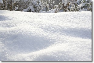
Weather Topic: What is Snow?
Home - Education - Precipitation - Snow
 Next Topic: Stratocumulus Clouds
Snow is precipitation taking the form of ice crystals. Each ice crystal, or snowflake,
has unique characteristics, but all of them grow in a hexagonal structure.
Snowfall can last for sustained periods of time and result in significant buildup
of snow on the ground.
On the earth's surface, snow starts out light and powdery, but as it begins to melt
it tends to become more granular, producing small bits of ice which have the consistency of
sand. After several cycles of melting and freezing, snow can become very dense
and ice-like, commonly known as snow pack.
Next Topic: Stratocumulus Clouds
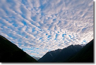
Weather Topic: What are Stratus Clouds?
Home - Education - Cloud Types - Stratus Clouds
 Next Topic: Wall Clouds
Stratus clouds are similar to altostratus clouds, but form at a
lower altitude and are identified by their fog-like appearance, lacking the
distinguishing features of most clouds.
Stratus clouds are wider than most clouds, and their base has a smooth, uniform
look which is lighter in color than a nimbostratus cloud.
The presence of a stratus cloud indicates the possibility of minor precipitation,
such as drizzle, but heavier precipitation does not typically arrive in the form
of a stratus cloud.
Next Topic: Wall Clouds
Current conditions powered by WeatherAPI.com


