Weather Alert in Michigan
Special Weather Statement issued June 19 at 6:40PM EDT by NWS Detroit/Pontiac MI
AREAS AFFECTED: Shiawassee; Genesee; Lapeer; Livingston; Oakland; Macomb
DESCRIPTION: At 638 PM EDT, Doppler radar indicated clusters of strong thunderstorms along a line extending from near Goodrich to near Gaines. Movement was southeast at 25 mph. HAZARD...Winds in excess of 40 mph and pea size hail. SOURCE...Radar indicated. IMPACT...Gusty winds could knock down tree limbs. Minor damage to outdoor objects is possible. Strong thunderstorms will be near... Grand Blanc, Linden, Goodrich, Ortonville, Byron, Gaines, and Lake Fenton around 640 PM EDT. Fenton and Holly around 645 PM EDT. Oxford around 700 PM EDT. Clarkston around 715 PM EDT. Other locations impacted by these storms include Rankin, Holly State Recreation Area, Ray Center, Rose Center, Washington, Auburn Hills, Conway Township, Lake Angelus, Genesee, and Leonard.
INSTRUCTION: If outdoors, consider seeking shelter inside a building.
Want more detail? Get the Complete 7 Day and Night Detailed Forecast!
Current U.S. National Radar--Current
The Current National Weather Radar is shown below with a UTC Time (subtract 5 hours from UTC to get Eastern Time).

National Weather Forecast--Current
The Current National Weather Forecast and National Weather Map are shown below.

National Weather Forecast for Tomorrow
Tomorrow National Weather Forecast and Tomorrow National Weather Map are show below.

North America Water Vapor (Moisture)
This map shows recent moisture content over North America. Bright and colored areas show high moisture (ie, clouds); brown indicates very little moisture present; black indicates no moisture.

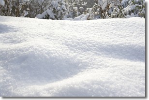
Weather Topic: What is Snow?
Home - Education - Precipitation - Snow
 Next Topic: Stratocumulus Clouds
Snow is precipitation taking the form of ice crystals. Each ice crystal, or snowflake,
has unique characteristics, but all of them grow in a hexagonal structure.
Snowfall can last for sustained periods of time and result in significant buildup
of snow on the ground.
On the earth's surface, snow starts out light and powdery, but as it begins to melt
it tends to become more granular, producing small bits of ice which have the consistency of
sand. After several cycles of melting and freezing, snow can become very dense
and ice-like, commonly known as snow pack.
Next Topic: Stratocumulus Clouds
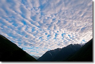
Weather Topic: What are Stratus Clouds?
Home - Education - Cloud Types - Stratus Clouds
 Next Topic: Wall Clouds
Stratus clouds are similar to altostratus clouds, but form at a
lower altitude and are identified by their fog-like appearance, lacking the
distinguishing features of most clouds.
Stratus clouds are wider than most clouds, and their base has a smooth, uniform
look which is lighter in color than a nimbostratus cloud.
The presence of a stratus cloud indicates the possibility of minor precipitation,
such as drizzle, but heavier precipitation does not typically arrive in the form
of a stratus cloud.
Next Topic: Wall Clouds
Current conditions powered by WeatherAPI.com


