Weather Alert in Colorado
Fire Weather Watch issued March 31 at 1:15PM MDT until April 2 at 8:00PM MDT by NWS Pueblo CO
AREAS AFFECTED: Southern El Paso County Including Fort Carson and Colorado Springs; Pueblo County Including Pueblo; Huerfano County Including Walsenburg; Western Las Animas County Including Trinidad and Thatcher; Crowley County Including Ordway; Otero County Including La Junta and Western Comanche Grasslands; Eastern Las Animas County Including Pinon Canyon; Kiowa County Including Eads; Bent County Including Las Animas; Prowers County Including Lamar; Baca County Including Springfield and Eastern Comanche Grasslands
DESCRIPTION: The National Weather Service in Pueblo has issued a Fire Weather Watch for gusty winds and low relative humidity, which is in effect from Thursday afternoon through Thursday evening. * AFFECTED AREA...Fire Weather Zones 227, 228, 229, 230, 231, 232, 233, 234, 235, 236 and 237. * WINDS...Southwest 15 to 25 mph with gusts up to 40 mph. * RELATIVE HUMIDITY...As low as 11 percent. * IMPACTS...Elevated fire danger is expected. Fires will catch and spread rapidly and erratically.
INSTRUCTION: A Fire Weather Watch means that critical fire weather conditions are forecast to occur. Listen for later forecasts and possible Red Flag Warnings.
Want more detail? Get the Complete 7 Day and Night Detailed Forecast!
Current U.S. National Radar--Current
The Current National Weather Radar is shown below with a UTC Time (subtract 5 hours from UTC to get Eastern Time).

National Weather Forecast--Current
The Current National Weather Forecast and National Weather Map are shown below.

National Weather Forecast for Tomorrow
Tomorrow National Weather Forecast and Tomorrow National Weather Map are show below.

North America Water Vapor (Moisture)
This map shows recent moisture content over North America. Bright and colored areas show high moisture (ie, clouds); brown indicates very little moisture present; black indicates no moisture.

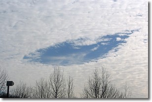
Weather Topic: What are Hole Punch Clouds?
Home - Education - Cloud Types - Hole Punch Clouds
 Next Topic: Mammatus Clouds
A hole punch cloud is an unusual occurrence when a disk-shaped
hole appears in a cirrostratus, cirrocumulus, or altocumulus cloud.
When part of the cloud forms ice crystals, water droplets in the surrounding area
of the cloud evaporate. The effect of this process produces a large elliptical
gap in the cloud. The hole punch cloud formation is rare, but it is not specific
to any geographic area.
Other names which have been used to describe this phenomena include fallstreak hole,
skypunch, and cloud hole.
Next Topic: Mammatus Clouds
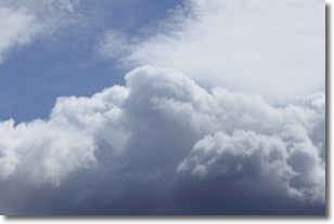
Weather Topic: What are Nimbostratus Clouds?
Home - Education - Cloud Types - Nimbostratus Clouds
 Next Topic: Precipitation
A nimbostratus cloud is similar to a stratus cloud in its formless,
smooth appearance. However, a nimbostratus cloud is darker than a stratus cloud,
because it is thicker.
Unlike a stratus cloud, a nimbostratus cloud typically brings with it the threat
of moderate to heavy precipitation. In some cases, the precipitation may evaporate
before reaching the ground, a phenomenon known as virga.
Next Topic: Precipitation
Current conditions powered by WeatherAPI.com


