Weather Alert in Nevada
Red Flag Warning issued June 19 at 1:15AM PDT until June 20 at 11:00PM PDT by NWS Elko NV
AREAS AFFECTED: White Pine and Northeast Nye Counties; Northern Nye County - Mojave; Central Nevada - Toiyabe; Central Elko County; Eastern Elko County
DESCRIPTION: ...RED FLAG WARNING FOR STRONG WIND AND LOW RELATIVE HUMIDITY CONDITIONS THURSDAY AND FRIDAY... A strong low pressure system will increase southwesterly wind speeds dramatically on Thursday and Friday across northeastern and central Nevada. Combined with dry conditions and low relative humidity values across the region, critical fire weather conditions will exist in the warned locations midday Thursday through Friday night. Thursday afternoon fire weather conditions will be aggravated by hot temperatures in the upper 90s to near triple digits for southern portions of Elko County. There will be a break in high winds overnight Thursday into Friday but wind speeds will again increase Friday afternoon, becoming slightly stronger than Thursday. * AFFECTED AREA...Fire weather zones 425, 426, 427, 469, and 470. * WIND...THURSDAY: Sustained wind speeds of 25-30 mph with wind gusts ranging 35-40 mph. FRIDAY: Sustained wind speeds of 25-30 mph with gusts of 40-45 mph. * HUMIDITY...Thursday and Friday afternoon relative humidity values range from 4% to 12%. * IMPACTS...Any fires that develop will likely spread rapidly. Outdoor burning is not recommended.
INSTRUCTION: A red flag warning means that critical fire weather conditions are either occurring now, or will shortly. A combination of strong winds, low relative humidity, and warm temperatures can contribute to extreme fire behavior.
Want more detail? Get the Complete 7 Day and Night Detailed Forecast!
Current U.S. National Radar--Current
The Current National Weather Radar is shown below with a UTC Time (subtract 5 hours from UTC to get Eastern Time).

National Weather Forecast--Current
The Current National Weather Forecast and National Weather Map are shown below.

National Weather Forecast for Tomorrow
Tomorrow National Weather Forecast and Tomorrow National Weather Map are show below.

North America Water Vapor (Moisture)
This map shows recent moisture content over North America. Bright and colored areas show high moisture (ie, clouds); brown indicates very little moisture present; black indicates no moisture.

Weather Topic: What is Freezing Rain?
Home - Education - Precipitation - Freezing Rain
 Next Topic: Graupel
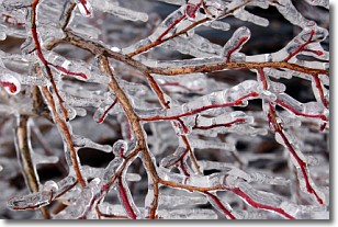
Freezing rain is a condition where precipitation which has fallen in the form of
water droplets reaches temperatures which are below freezing and freezes upon
coming into contact
with surface objects. The result of this precipitation is a glaze of ice which
can be damaging to plants and man-made structures. A severe onset of freezing
rain which results in a very thick glaze of ice is known as an ice storm.
Next Topic: Graupel
Weather Topic: What is Hail?
Home - Education - Precipitation - Hail
 Next Topic: Hole Punch Clouds
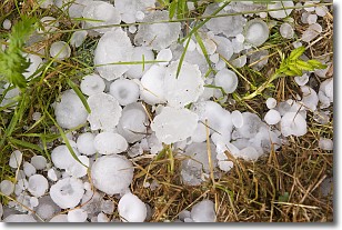
Hail is a form of precipitation which is recognized by large solid balls or
clumps of ice. Hail is created by thunderstorm clouds with strong updrafts of wind.
As the hailstones remain in the updraft, ice is deposited onto them until their
weight becomes heavy enough for them to fall to the earth's surface.
Hail storms can cause significant damage to crops, aircrafts, and man-made structures,
despite the fact that the duration is usually less than ten minutes.
Next Topic: Hole Punch Clouds
Current conditions powered by WeatherAPI.com


