Weather Alert in Colorado
Fire Weather Watch issued March 31 at 8:59PM MDT until April 2 at 8:00PM MDT by NWS Goodland KS
AREAS AFFECTED: Yuma; Kit Carson County; Cheyenne; Wallace; Greeley; Wichita
DESCRIPTION: Winds from the south Thursday afternoon and early evening are forecast to be around 15-25 MPH sustained with gusts up to 35 MPH. RH values are currently forecast to dry into the low to mid teens as temperatures warm into the mid to upper 70s. * AFFECTED AREA...Fire Weather Zones 027 Wallace, 041 Greeley, 042 Wichita, 252 Yuma, 253 Kit Carson and 254 Cheyenne CO. * TIMING...From Thursday afternoon through Thursday evening. * WINDS...South 15 to 25 mph with gusts up to 35 mph. * RELATIVE HUMIDITY...As low as 13 percent. * IMPACTS...Unpredictable fire behavior. Any fires that develop may rapidly grow and spread out of control.
INSTRUCTION: A Fire Weather Watch means that critical fire weather conditions are forecast to occur. Listen for later forecasts and possible red flag warnings.
Want more detail? Get the Complete 7 Day and Night Detailed Forecast!
Current U.S. National Radar--Current
The Current National Weather Radar is shown below with a UTC Time (subtract 5 hours from UTC to get Eastern Time).

National Weather Forecast--Current
The Current National Weather Forecast and National Weather Map are shown below.

National Weather Forecast for Tomorrow
Tomorrow National Weather Forecast and Tomorrow National Weather Map are show below.

North America Water Vapor (Moisture)
This map shows recent moisture content over North America. Bright and colored areas show high moisture (ie, clouds); brown indicates very little moisture present; black indicates no moisture.

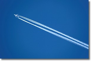
Weather Topic: What are Contrails?
Home - Education - Cloud Types - Contrails
 Next Topic: Cumulonimbus Clouds
A contrail is an artificial cloud, created by the passing of an
aircraft.
Contrails form because water vapor in the exhaust of aircraft engines is suspended
in the air under certain temperatures and humidity conditions. These contrails
are called exhaust contrails.
Another type of contrail can form due to a temporary reduction in air pressure
moving over the plane's surface, causing condensation.
These are called aerodynamic contrails.
When you can see your breath on a cold day, it is also because of condensation.
The reason contrails last longer than the condensation from your breath is
because the water in contrails freezes into ice particles.
Next Topic: Cumulonimbus Clouds
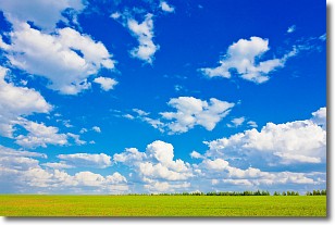
Weather Topic: What are Cumulus Clouds?
Home - Education - Cloud Types - Cumulus Clouds
 Next Topic: Drizzle
Cumulus clouds are fluffy and textured with rounded tops, and
may have flat bottoms. The border of a cumulus cloud
is clearly defined, and can have the appearance of cotton or cauliflower.
Cumulus clouds form at low altitudes (rarely above 2 km) but can grow very tall,
becoming cumulus congestus and possibly the even taller cumulonimbus clouds.
When cumulus clouds become taller, they have a greater chance of producing precipitation.
Next Topic: Drizzle
Current conditions powered by WeatherAPI.com


