Weather Alert in Colorado
Fire Weather Watch issued March 31 at 8:59PM MDT until April 2 at 8:00PM MDT by NWS Goodland KS
AREAS AFFECTED: Yuma; Kit Carson County; Cheyenne; Wallace; Greeley; Wichita
DESCRIPTION: Winds from the south Thursday afternoon and early evening are forecast to be around 15-25 MPH sustained with gusts up to 35 MPH. RH values are currently forecast to dry into the low to mid teens as temperatures warm into the mid to upper 70s. * AFFECTED AREA...Fire Weather Zones 027 Wallace, 041 Greeley, 042 Wichita, 252 Yuma, 253 Kit Carson and 254 Cheyenne CO. * TIMING...From Thursday afternoon through Thursday evening. * WINDS...South 15 to 25 mph with gusts up to 35 mph. * RELATIVE HUMIDITY...As low as 13 percent. * IMPACTS...Unpredictable fire behavior. Any fires that develop may rapidly grow and spread out of control.
INSTRUCTION: A Fire Weather Watch means that critical fire weather conditions are forecast to occur. Listen for later forecasts and possible red flag warnings.
Want more detail? Get the Complete 7 Day and Night Detailed Forecast!
Current U.S. National Radar--Current
The Current National Weather Radar is shown below with a UTC Time (subtract 5 hours from UTC to get Eastern Time).

National Weather Forecast--Current
The Current National Weather Forecast and National Weather Map are shown below.

National Weather Forecast for Tomorrow
Tomorrow National Weather Forecast and Tomorrow National Weather Map are show below.

North America Water Vapor (Moisture)
This map shows recent moisture content over North America. Bright and colored areas show high moisture (ie, clouds); brown indicates very little moisture present; black indicates no moisture.

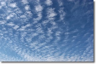
Weather Topic: What are Cirrocumulus Clouds?
Home - Education - Cloud Types - Cirrocumulus Clouds
 Next Topic: Cirrostratus Clouds
Cirrocumulus clouds form at high altitudes (usually around 5 km)
and have distinguishing characteristics displayed in a fine layer of
small cloud patches. These small cloud patches are sometimes referred to as
"cloudlets" in relation to the whole cloud formation.
Cirrocumulus clouds are formed from ice crystals and water droplets. Often, the
water droplets in the cloud freeze into ice crystals and the cloud becomes a
cirrostratus cloud. Because of this common occurrence, cirrocumulus cloud
formations generally pass rapidly.
Next Topic: Cirrostratus Clouds
Weather Topic: What are Cirrus Clouds?
Home - Education - Cloud Types - Cirrus Clouds
 Next Topic: Condensation
Cirrus clouds are high-level clouds that occur above 20,000 feet
and are composed mainly of ice crystals.
They are thin and wispy in appearance.
What do they indicate?
They are often the first sign of an approaching storm.
Next Topic: Condensation
Current conditions powered by WeatherAPI.com


