Weather Alert in Minnesota
Winter Weather Advisory issued April 1 at 3:11AM CDT until April 2 at 12:00PM CDT by NWS Twin Cities/Chanhassen MN
AREAS AFFECTED: Sherburne; Isanti; Chisago; Wright; Hennepin; Anoka; Ramsey; Renville; McLeod; Sibley; Carver; Redwood; Brown; Nicollet; Watonwan; Blue Earth; Waseca; Steele
DESCRIPTION: ...MESSY SPRING SYSTEM BRINGS FREEZING RAIN, SLEET, AND SNOWTO PORTIONS OF MINNESOTA AND WISCONSIN TONIGHT THROUGH THURSDAY... .A strong spring system brings a variety of precipitation types to the region tonight through Thursday. While there is still some uncertainty in the exact track of the low, mainly snow & sleet is expected across central Minnesota, while a mix of freezing rain, sleet, & snow is expected for southern Minnesota, the Twin Cities metro, & western Wisconsin. The greatest travel impacts are expected across eastern Minnesota & west-central Wisconsin where icing amounts around 0.25" are likely, along with sleet & snow at times. This will lead to very slick roads, as well as the possibility of some downed tree branches & power outages. Elsewhere, freezing rain accumulations around 0.1" along with an inch or two of sleet & snow will lead to slick roads late Wednesday night through Thursday morning. * WHAT...Mixed precipitation expected. Total snow accumulations up to one inch, sleet accumulations around one half of an inch, and ice accumulations up to two tenths of an inch. * WHERE...Portions of central, east central, south central, and southwest Minnesota. * WHEN...From midnight tonight to noon CDT Thursday. * IMPACTS...Plan on slippery road conditions. The hazardous conditions will impact the Thursday morning commute.
INSTRUCTION: Slow down and use caution while traveling. Call 5 1 1 or visit 511mn.org for road conditions. Be prepared for slippery roads. Slow down and use caution while driving. If you are going outside, watch your first few steps taken on stairs, sidewalks, and driveways. These surfaces could be icy and slippery, increasing your risk of a fall and injury.
Want more detail? Get the Complete 7 Day and Night Detailed Forecast!
Current U.S. National Radar--Current
The Current National Weather Radar is shown below with a UTC Time (subtract 5 hours from UTC to get Eastern Time).

National Weather Forecast--Current
The Current National Weather Forecast and National Weather Map are shown below.

National Weather Forecast for Tomorrow
Tomorrow National Weather Forecast and Tomorrow National Weather Map are show below.

North America Water Vapor (Moisture)
This map shows recent moisture content over North America. Bright and colored areas show high moisture (ie, clouds); brown indicates very little moisture present; black indicates no moisture.

Weather Topic: What are Altostratus Clouds?
Home - Education - Cloud Types - Altostratus Clouds
 Next Topic: Cirrocumulus Clouds
Altostratus clouds form at mid to high-level altitudes
(between 2 and 7 km) and are created by a warm, stable air mass which causes
water vapor
to condense as it rise through the atmosphere. Usually altostratus clouds are
featureless sheets characterized by a uniform color.
In some cases, wind punching through the cloud formation may give it a waved
appearance, called altostratus undulatus. Altostratus clouds
are commonly seen with other cloud formations accompanying them.
Next Topic: Cirrocumulus Clouds
Weather Topic: What are Cirrostratus Clouds?
Home - Education - Cloud Types - Cirrostratus Clouds
 Next Topic: Cirrus Clouds
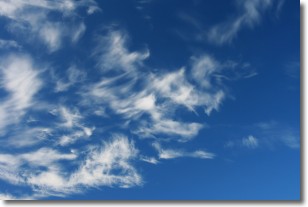
Cirrostratus clouds are high, thin clouds that form above
20,000 feet and are made mostly of ice crystals. They sometimes look like giant
feathers, horse tails, or curls of hair in the sky.
These clouds are pushed by the jet stream and can move at high speeds reaching
100 mph.
What do they indicate?
They indicate that a precipitation is likely within 24 hours.
Next Topic: Cirrus Clouds
Current conditions powered by WeatherAPI.com


