Weather Alert in Iowa
Flood Warning issued August 1 at 9:15PM CDT until August 8 at 9:00PM CDT by NWS Quad Cities IA IL
AREAS AFFECTED: Louisa, IA
DESCRIPTION: ...The Flood Warning continues for the following rivers in Iowa... Wapsipinicon River near De Witt 4S affecting Clinton and Scott Counties. Cedar River near Conesville affecting Muscatine and Louisa Counties. Cedar River at Cedar Rapids affecting Linn County. Iowa River at Oakville affecting Louisa County. Iowa River at Wapello affecting Louisa County. Iowa River at Marengo affecting Benton and Iowa Counties. ...The Flood Warning is cancelled for the following rivers in Iowa... North Skunk River near Sigourney affecting Keokuk County. ...The Flood Warning is expired for the following rivers in Iowa... English River at Kalona affecting Washington and Johnson Counties. * WHAT...Minor flooding is occurring. * WHERE...Iowa River at Wapello. * WHEN...Until Friday, August 08. * IMPACTS...At 22.0 feet, Water affects residences near the U.S. Highway 61 bridge. * ADDITIONAL DETAILS... - At 8:15 PM CDT Friday the stage was 21.9 feet. - Forecast...The river has risen to 22.0 feet Friday evening and will generally hold steady through midweek before falling. - Flood stage is 21.0 feet.
INSTRUCTION: Turn around, don't drown when encountering flooded roads. Most flood deaths occur in vehicles. Caution is urged when walking near riverbanks. The next statement will be issued by this evening at 1015 PM CDT.
Want more detail? Get the Complete 7 Day and Night Detailed Forecast!
Current U.S. National Radar--Current
The Current National Weather Radar is shown below with a UTC Time (subtract 5 hours from UTC to get Eastern Time).

National Weather Forecast--Current
The Current National Weather Forecast and National Weather Map are shown below.

National Weather Forecast for Tomorrow
Tomorrow National Weather Forecast and Tomorrow National Weather Map are show below.

North America Water Vapor (Moisture)
This map shows recent moisture content over North America. Bright and colored areas show high moisture (ie, clouds); brown indicates very little moisture present; black indicates no moisture.

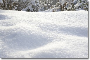
Weather Topic: What is Snow?
Home - Education - Precipitation - Snow
 Next Topic: Stratocumulus Clouds
Snow is precipitation taking the form of ice crystals. Each ice crystal, or snowflake,
has unique characteristics, but all of them grow in a hexagonal structure.
Snowfall can last for sustained periods of time and result in significant buildup
of snow on the ground.
On the earth's surface, snow starts out light and powdery, but as it begins to melt
it tends to become more granular, producing small bits of ice which have the consistency of
sand. After several cycles of melting and freezing, snow can become very dense
and ice-like, commonly known as snow pack.
Next Topic: Stratocumulus Clouds
Weather Topic: What are Stratus Clouds?
Home - Education - Cloud Types - Stratus Clouds
 Next Topic: Wall Clouds
Stratus clouds are similar to altostratus clouds, but form at a
lower altitude and are identified by their fog-like appearance, lacking the
distinguishing features of most clouds.
Stratus clouds are wider than most clouds, and their base has a smooth, uniform
look which is lighter in color than a nimbostratus cloud.
The presence of a stratus cloud indicates the possibility of minor precipitation,
such as drizzle, but heavier precipitation does not typically arrive in the form
of a stratus cloud.
Next Topic: Wall Clouds
Current conditions powered by WeatherAPI.com


