Weather Alert in Montana
Winter Weather Advisory issued March 31 at 8:34PM MDT until April 1 at 9:00AM MDT by NWS Billings MT
AREAS AFFECTED: Northern Big Horn; Southern Rosebud; Southern Big Horn; Southeastern Carbon; Bighorn Canyon; Southwestern Yellowstone
DESCRIPTION: * WHAT...Mixed precipitation expected, including pockets of freezing rain. Total snow accumulations less than 1 inch. Total ice accumulations of a few hundredths possible. The greatest ice accumulations are forecast along Highway 310 through Belfry as well as along I-90 south and east of Billings. * WHERE...Portions of south central and southeast Montana. * WHEN...Until 9 AM MDT Wednesday. * IMPACTS...Travel will be impacted by poor visibility and slick or slushy conditions on roads. This includes I-90 from Crow Agency to Sheridan, and US-212 over Lame Deer Divide. * ADDITIONAL DETAILS...Potentially heavier ice accumulations are most likely along I-90 southeast of Billings, especially from Hardin to the Wyoming border.
INSTRUCTION: YtSlow down and use caution while traveling. For the latest road conditions, call 5 1 1.
Want more detail? Get the Complete 7 Day and Night Detailed Forecast!
Current U.S. National Radar--Current
The Current National Weather Radar is shown below with a UTC Time (subtract 5 hours from UTC to get Eastern Time).

National Weather Forecast--Current
The Current National Weather Forecast and National Weather Map are shown below.

National Weather Forecast for Tomorrow
Tomorrow National Weather Forecast and Tomorrow National Weather Map are show below.

North America Water Vapor (Moisture)
This map shows recent moisture content over North America. Bright and colored areas show high moisture (ie, clouds); brown indicates very little moisture present; black indicates no moisture.

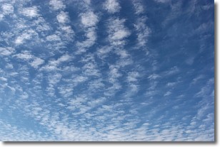
Weather Topic: What are Cirrocumulus Clouds?
Home - Education - Cloud Types - Cirrocumulus Clouds
 Next Topic: Cirrostratus Clouds
Cirrocumulus clouds form at high altitudes (usually around 5 km)
and have distinguishing characteristics displayed in a fine layer of
small cloud patches. These small cloud patches are sometimes referred to as
"cloudlets" in relation to the whole cloud formation.
Cirrocumulus clouds are formed from ice crystals and water droplets. Often, the
water droplets in the cloud freeze into ice crystals and the cloud becomes a
cirrostratus cloud. Because of this common occurrence, cirrocumulus cloud
formations generally pass rapidly.
Next Topic: Cirrostratus Clouds
Weather Topic: What are Cirrus Clouds?
Home - Education - Cloud Types - Cirrus Clouds
 Next Topic: Condensation
Cirrus clouds are high-level clouds that occur above 20,000 feet
and are composed mainly of ice crystals.
They are thin and wispy in appearance.
What do they indicate?
They are often the first sign of an approaching storm.
Next Topic: Condensation
Current conditions powered by WeatherAPI.com


