Weather Alert in Montana
Winter Weather Advisory issued March 31 at 8:34PM MDT until April 1 at 9:00AM MDT by NWS Billings MT
AREAS AFFECTED: Northern Big Horn; Southern Rosebud; Southern Big Horn; Southeastern Carbon; Bighorn Canyon; Southwestern Yellowstone
DESCRIPTION: * WHAT...Mixed precipitation expected, including pockets of freezing rain. Total snow accumulations less than 1 inch. Total ice accumulations of a few hundredths possible. The greatest ice accumulations are forecast along Highway 310 through Belfry as well as along I-90 south and east of Billings. * WHERE...Portions of south central and southeast Montana. * WHEN...Until 9 AM MDT Wednesday. * IMPACTS...Travel will be impacted by poor visibility and slick or slushy conditions on roads. This includes I-90 from Crow Agency to Sheridan, and US-212 over Lame Deer Divide. * ADDITIONAL DETAILS...Potentially heavier ice accumulations are most likely along I-90 southeast of Billings, especially from Hardin to the Wyoming border.
INSTRUCTION: YtSlow down and use caution while traveling. For the latest road conditions, call 5 1 1.
Want more detail? Get the Complete 7 Day and Night Detailed Forecast!
Current U.S. National Radar--Current
The Current National Weather Radar is shown below with a UTC Time (subtract 5 hours from UTC to get Eastern Time).

National Weather Forecast--Current
The Current National Weather Forecast and National Weather Map are shown below.

National Weather Forecast for Tomorrow
Tomorrow National Weather Forecast and Tomorrow National Weather Map are show below.

North America Water Vapor (Moisture)
This map shows recent moisture content over North America. Bright and colored areas show high moisture (ie, clouds); brown indicates very little moisture present; black indicates no moisture.

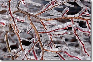
Weather Topic: What is Freezing Rain?
Home - Education - Precipitation - Freezing Rain
 Next Topic: Graupel
Freezing rain is a condition where precipitation which has fallen in the form of
water droplets reaches temperatures which are below freezing and freezes upon
coming into contact
with surface objects. The result of this precipitation is a glaze of ice which
can be damaging to plants and man-made structures. A severe onset of freezing
rain which results in a very thick glaze of ice is known as an ice storm.
Next Topic: Graupel
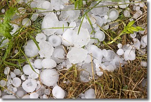
Weather Topic: What is Hail?
Home - Education - Precipitation - Hail
 Next Topic: Hole Punch Clouds
Hail is a form of precipitation which is recognized by large solid balls or
clumps of ice. Hail is created by thunderstorm clouds with strong updrafts of wind.
As the hailstones remain in the updraft, ice is deposited onto them until their
weight becomes heavy enough for them to fall to the earth's surface.
Hail storms can cause significant damage to crops, aircrafts, and man-made structures,
despite the fact that the duration is usually less than ten minutes.
Next Topic: Hole Punch Clouds
Current conditions powered by WeatherAPI.com


