Weather Alert in Montana
Winter Weather Advisory issued March 31 at 8:34PM MDT until April 1 at 9:00AM MDT by NWS Billings MT
AREAS AFFECTED: Northern Big Horn; Southern Rosebud; Southern Big Horn; Southeastern Carbon; Bighorn Canyon; Southwestern Yellowstone
DESCRIPTION: * WHAT...Mixed precipitation expected, including pockets of freezing rain. Total snow accumulations less than 1 inch. Total ice accumulations of a few hundredths possible. The greatest ice accumulations are forecast along Highway 310 through Belfry as well as along I-90 south and east of Billings. * WHERE...Portions of south central and southeast Montana. * WHEN...Until 9 AM MDT Wednesday. * IMPACTS...Travel will be impacted by poor visibility and slick or slushy conditions on roads. This includes I-90 from Crow Agency to Sheridan, and US-212 over Lame Deer Divide. * ADDITIONAL DETAILS...Potentially heavier ice accumulations are most likely along I-90 southeast of Billings, especially from Hardin to the Wyoming border.
INSTRUCTION: YtSlow down and use caution while traveling. For the latest road conditions, call 5 1 1.
Want more detail? Get the Complete 7 Day and Night Detailed Forecast!
Current U.S. National Radar--Current
The Current National Weather Radar is shown below with a UTC Time (subtract 5 hours from UTC to get Eastern Time).

National Weather Forecast--Current
The Current National Weather Forecast and National Weather Map are shown below.

National Weather Forecast for Tomorrow
Tomorrow National Weather Forecast and Tomorrow National Weather Map are show below.

North America Water Vapor (Moisture)
This map shows recent moisture content over North America. Bright and colored areas show high moisture (ie, clouds); brown indicates very little moisture present; black indicates no moisture.

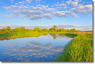
Weather Topic: What are Stratocumulus Clouds?
Home - Education - Cloud Types - Stratocumulus Clouds
 Next Topic: Stratus Clouds
Stratocumulus clouds are similar to altocumulus clouds in their
fluffy appearance, but have a slightly darker shade due to their additional mass.
A good way to distinguish the two cloud types is to hold your hand out and measure
the size of an individual cloud; if it is the size of your thumb it is generally
an altocumulus cloud, if it is the size of your hand it is generally a
stratocumulus cloud.
It is uncommon for stratocumulus clouds to produce precipitation, but if they do
it is usually a light rain or snow.
Next Topic: Stratus Clouds
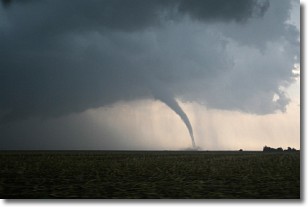
Weather Topic: What are Wall Clouds?
Home - Education - Cloud Types - Wall Clouds
 Next Topic: Altocumulus Clouds
A wall cloud forms underneath the base of a cumulonimbus cloud,
and can be a hotbed for deadly tornadoes.
Wall clouds are formed by air flowing into the cumulonimbus clouds, which can
result in the wall cloud descending from the base of the cumulonimbus cloud, or
rising fractus clouds which join to the base of the storm cloud as the wall cloud
takes shape.
Wall clouds can be very large, and in the Northern Hemisphere they generally
form at the southern edge of cumulonimbus clouds.
Next Topic: Altocumulus Clouds
Current conditions powered by WeatherAPI.com


