Weather Alert in Pennsylvania
Severe Thunderstorm Warning issued April 29 at 4:34PM EDT until April 29 at 5:30PM EDT by NWS Pittsburgh PA
AREAS AFFECTED: Armstrong, PA; Forest, PA; Lawrence, PA; Mercer, PA; Venango, PA
DESCRIPTION: SVRPBZ The National Weather Service in Pittsburgh has issued a * Severe Thunderstorm Warning for... Southeastern Mercer County in northwestern Pennsylvania... Venango County in northwestern Pennsylvania... Lawrence County in western Pennsylvania... Northwestern Armstrong County in west central Pennsylvania... Western Forest County in northwestern Pennsylvania... * Until 530 PM EDT. * At 434 PM EDT, severe thunderstorms were located along a line extending from 8 miles north of Sugarcreek to near New Wilmington, moving east at 45 mph. HAZARD...60 mph wind gusts. SOURCE...Radar indicated. IMPACT...Expect damage to trees and power lines, resulting in some power outages. * Locations impacted include... New Castle, Oil City, Grove City, Franklin, Ellwood City, Sugarcreek, New Wilmington, Oakwood, New Castle Northwest, Tionesta, Mercer, Big Beaver, New Beaver, Pulaski, Hasson Heights, Ellport, Bessemer, Stoneboro, Seneca, and New Bedford. This includes the following highways... Pennsylvania Turnpike between mile markers 1 and 8. Interstate 79 in Pennsylvania between mile markers 106 and 132. Interstate 80 in Pennsylvania between mile markers 6 and 44. Interstate 376 in Pennsylvania between mile markers 2 and 24.
INSTRUCTION: For your protection move to an interior room on the lowest floor of a building. Please report severe weather by calling 412-262-1988, posting to the NWS Pittsburgh Facebook page, or using X @NWSPITTSBURGH.
Want more detail? Get the Complete 7 Day and Night Detailed Forecast!
Current U.S. National Radar--Current
The Current National Weather Radar is shown below with a UTC Time (subtract 5 hours from UTC to get Eastern Time).

National Weather Forecast--Current
The Current National Weather Forecast and National Weather Map are shown below.

National Weather Forecast for Tomorrow
Tomorrow National Weather Forecast and Tomorrow National Weather Map are show below.

North America Water Vapor (Moisture)
This map shows recent moisture content over North America. Bright and colored areas show high moisture (ie, clouds); brown indicates very little moisture present; black indicates no moisture.

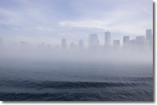
Weather Topic: What is Fog?
Home - Education - Cloud Types - Fog
 Next Topic: Fractus Clouds
Fog is technically a type of stratus cloud, which lies along the
ground and obscures visibility.
It is usually created when humidity in the air condenses into tiny water droplets.
Because of this, some places are more prone to foggy weather, such as regions
close to a body of water.
Fog is similar to mist; both are the appearance of water droplets suspended in
the air, but fog is the term applied to the condition when visibility is less than 1 km.
Next Topic: Fractus Clouds
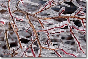
Weather Topic: What is Freezing Rain?
Home - Education - Precipitation - Freezing Rain
 Next Topic: Graupel
Freezing rain is a condition where precipitation which has fallen in the form of
water droplets reaches temperatures which are below freezing and freezes upon
coming into contact
with surface objects. The result of this precipitation is a glaze of ice which
can be damaging to plants and man-made structures. A severe onset of freezing
rain which results in a very thick glaze of ice is known as an ice storm.
Next Topic: Graupel
Current conditions powered by WeatherAPI.com


