Weather Alert in Ohio
Flood Warning issued March 31 at 11:53PM EDT until April 1 at 11:21PM EDT by NWS Cleveland OH
AREAS AFFECTED: Lake, OH
DESCRIPTION: ...Forecast flooding changed from Minor to Moderate severity and increased in duration for the following rivers in Ohio... Chagrin River At Willoughby affecting Lake County. For the Chagrin River...including Willoughby...Moderate flooding is forecast. * WHAT...Moderate flooding is forecast. * WHERE...Chagrin River at Willoughby. * WHEN...Until late tomorrow evening. * IMPACTS...At 15.0 feet, Flood waters threaten properties along Dodd Road in Willoughby Hills. Properties on Riverside Drive impacted in Eastlake. * ADDITIONAL DETAILS... - At 11:15 PM EDT Tuesday the stage was 11.7 feet. - Forecast...The river is expected to rise to a crest of 15.0 feet tomorrow morning. It will then fall below flood stage tomorrow afternoon. - Flood stage is 12.0 feet. - Please visit www.weather.gov/safety/flood for flood safety and preparedness information.
INSTRUCTION: Turn around, don't drown when encountering flooded roads. Most flood deaths occur in vehicles. Be especially cautious at night when it is harder to recognize the dangers of flooding. To escape rising water, take the shortest path to higher ground. Additional information is available at www.weather.gov/cle. The next statement will be issued Wednesday morning at 1000 AM EDT.
Want more detail? Get the Complete 7 Day and Night Detailed Forecast!
Current U.S. National Radar--Current
The Current National Weather Radar is shown below with a UTC Time (subtract 5 hours from UTC to get Eastern Time).

National Weather Forecast--Current
The Current National Weather Forecast and National Weather Map are shown below.

National Weather Forecast for Tomorrow
Tomorrow National Weather Forecast and Tomorrow National Weather Map are show below.

North America Water Vapor (Moisture)
This map shows recent moisture content over North America. Bright and colored areas show high moisture (ie, clouds); brown indicates very little moisture present; black indicates no moisture.

Weather Topic: What is Graupel?
Home - Education - Precipitation - Graupel
 Next Topic: Hail
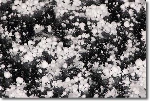
Graupel is a form of precipitation that is created by atmospheric conditions
which cause supercooled water droplets to contact snow crystals and freeze to
their surface.
Sometimes known as soft hail or snow pellets, graupel is delicate and easily
destroyed by touch. Whereas hail usually falls during severe weather, graupel
doesn't require such conditions to form, and can form in mild precipitation
similar to situations which produce snowfall.
Next Topic: Hail
Weather Topic: What are Hole Punch Clouds?
Home - Education - Cloud Types - Hole Punch Clouds
 Next Topic: Mammatus Clouds
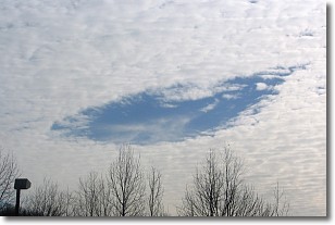
A hole punch cloud is an unusual occurrence when a disk-shaped
hole appears in a cirrostratus, cirrocumulus, or altocumulus cloud.
When part of the cloud forms ice crystals, water droplets in the surrounding area
of the cloud evaporate. The effect of this process produces a large elliptical
gap in the cloud. The hole punch cloud formation is rare, but it is not specific
to any geographic area.
Other names which have been used to describe this phenomena include fallstreak hole,
skypunch, and cloud hole.
Next Topic: Mammatus Clouds
Current conditions powered by WeatherAPI.com


