Weather Alert in Indiana
Flood Warning issued April 1 at 2:31AM EDT by NWS Northern Indiana
AREAS AFFECTED: Allen, IN; De Kalb, IN; Defiance, OH
DESCRIPTION: ...The National Weather Service in Northern Indiana has issued a Flood Warning for the following rivers in Ohio...Indiana... Saint Joseph River Ohio near Newville affecting De Kalb, Defiance and Allen IN Counties. Tiffin River at Stryker affecting Fulton OH, Williams and Defiance Counties. .Heavy rain has caused area rivers to rise. For the Saint Joseph River Ohio...including Newville...Minor flooding is forecast. For the Tiffin River...including Stryker...Minor flooding is forecast. * WHAT...Minor flooding is forecast. * WHERE...Saint Joseph River Ohio near Newville. * WHEN...From this evening until further notice. * IMPACTS...At 12.0 feet, DeKalb County Road 42 about 3 miles northeast of Newville floods. Agricultural and low lands flood along the St. Joseph River to the Cedarville Reservoir. * ADDITIONAL DETAILS... - At 2:00 AM EDT Wednesday the stage was 9.2 feet. - Forecast...The river is expected to rise above flood stage this evening and continue rising to a crest of 12.7 feet Friday evening. - Flood stage is 12.0 feet. - http://www.weather.gov/safety/flood
INSTRUCTION: Turn around, don't drown when encountering flooded roads. Most flood deaths occur in vehicles. Detailed river forecasts and additional information can be found at www.weather.gov/iwx under Rivers and Lakes. The next statement will be issued this evening at 845 PM EDT.
Want more detail? Get the Complete 7 Day and Night Detailed Forecast!
Current U.S. National Radar--Current
The Current National Weather Radar is shown below with a UTC Time (subtract 5 hours from UTC to get Eastern Time).

National Weather Forecast--Current
The Current National Weather Forecast and National Weather Map are shown below.

National Weather Forecast for Tomorrow
Tomorrow National Weather Forecast and Tomorrow National Weather Map are show below.

North America Water Vapor (Moisture)
This map shows recent moisture content over North America. Bright and colored areas show high moisture (ie, clouds); brown indicates very little moisture present; black indicates no moisture.

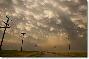
Weather Topic: What are Mammatus Clouds?
Home - Education - Cloud Types - Mammatus Clouds
 Next Topic: Nimbostratus Clouds
A mammatus cloud is a cloud with a unique feature which resembles
a web of pouches hanging along the base of the cloud.
In the United States, mammatus clouds tend to form in the warmer months, commonly
in the Midwest and eastern regions.
While they usually form at the bottom of a cumulonimbis cloud, they can also form
under altostratus, altocumulus, stratocumulus, and cirrus clouds. Mammatus clouds
warn that severe weather is close.
Next Topic: Nimbostratus Clouds
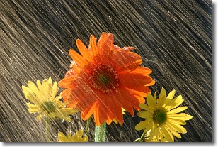
Weather Topic: What is Precipitation?
Home - Education - Precipitation - Precipitation
 Next Topic: Rain
Precipitation can refer to many different forms of water that
may fall from clouds. Precipitation occurs after a cloud has become saturated to
the point where its water particles are more dense than the air below the cloud.
In most cases, precipitation will reach the ground, but it is not uncommon for
precipitation to evaporate before it reaches the earth's surface.
When precipitation evaporates before it contacts the ground it is called Virga.
Graupel, hail, sleet, rain, drizzle, and snow are forms of precipitation, but fog
and mist are not considered precipitation because the water vapor which
constitutes them isn't dense enough to fall to the ground.
Next Topic: Rain
Current conditions powered by WeatherAPI.com


