Weather Alert in District of Columbia
Flood Watch issued June 19 at 11:37AM EDT until June 19 at 9:00PM EDT by NWS Baltimore MD/Washington DC
AREAS AFFECTED: District of Columbia; Southern Baltimore; Prince Georges; Anne Arundel; Central and Southeast Montgomery; Central and Southeast Howard; Fairfax; Arlington/Falls Church/Alexandria
DESCRIPTION: * WHAT...Flash flooding caused by excessive rainfall is possible. * WHERE...Washington DC, portions of Maryland, including the following areas, Anne Arundel, Central and Southeast Howard, Central and Southeast Montgomery, Prince Georges and Southern Baltimore, and portions of northern Virginia, including the following areas, Arlington/Falls Church/Alexandria and Fairfax. * WHEN...From 3 PM this afternoon to 9 PM EDT this evening. * IMPACTS...Excessive runoff may result in flooding of rivers, creeks, streams, and other low-lying and flood-prone locations. Flooding may occur in poor drainage and urban areas. * ADDITIONAL DETAILS... - Showers and thunderstorms may produce rainfall rates around 1 inch per hour, with localized totals of 2 to 3 inches possible in areas that receive multiple thunderstorms. This may result in rapid rises on small streams and creeks, and in urban and poor drainage areas. - Please visit www.weather.gov/safety/flood for flood safety and preparedness information.
INSTRUCTION: You should monitor later forecasts and be prepared to take action should Flash Flood Warnings be issued.
Want more detail? Get the Complete 7 Day and Night Detailed Forecast!
Current U.S. National Radar--Current
The Current National Weather Radar is shown below with a UTC Time (subtract 5 hours from UTC to get Eastern Time).

National Weather Forecast--Current
The Current National Weather Forecast and National Weather Map are shown below.

National Weather Forecast for Tomorrow
Tomorrow National Weather Forecast and Tomorrow National Weather Map are show below.

North America Water Vapor (Moisture)
This map shows recent moisture content over North America. Bright and colored areas show high moisture (ie, clouds); brown indicates very little moisture present; black indicates no moisture.

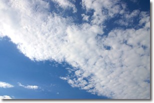
Weather Topic: What are Altocumulus Clouds?
Home - Education - Cloud Types - Altocumulus Clouds
 Next Topic: Altostratus Clouds
Similar to cirrocumulus clouds, altocumulus clouds are
characterized by cloud patches. They are distinguished by larger cloudlets
than cirrocumulus clouds but are still smaller than stratocumulus clouds.
Altocumulus clouds most commonly form in middle altitudes (between 2 and 5 km)
and may resemble, at times, the shape of a flying saucer.
These uncommon formations, called altocumulus lenticularis, are created by uplift
in the atmosphere and are most often seen in close proximity to mountains.
Next Topic: Altostratus Clouds
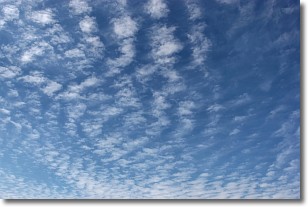
Weather Topic: What are Cirrocumulus Clouds?
Home - Education - Cloud Types - Cirrocumulus Clouds
 Next Topic: Cirrostratus Clouds
Cirrocumulus clouds form at high altitudes (usually around 5 km)
and have distinguishing characteristics displayed in a fine layer of
small cloud patches. These small cloud patches are sometimes referred to as
"cloudlets" in relation to the whole cloud formation.
Cirrocumulus clouds are formed from ice crystals and water droplets. Often, the
water droplets in the cloud freeze into ice crystals and the cloud becomes a
cirrostratus cloud. Because of this common occurrence, cirrocumulus cloud
formations generally pass rapidly.
Next Topic: Cirrostratus Clouds
Current conditions powered by WeatherAPI.com


