Weather Alert in Montana
Winter Storm Watch issued June 19 at 3:31AM MDT until June 22 at 12:00PM MDT by NWS Great Falls MT
AREAS AFFECTED: East Glacier Park Region
DESCRIPTION: * WHAT...Heavy, wet snow expected. Total snow accumulations up to 12 inches at and above 6000 feet, with up to 4 inches across the valley floors of Glacier National Park. Winds gusting as high as 45 mph * WHERE...East Glacier Park Region Zone. * WHEN...From Saturday afternoon through Sunday morning. * IMPACTS...Going to the Sun Road, Highway 49 from East Glacier Park to Kiowa and Highway 89 from Kiowa to St Mary will be impacted from this snowfall. Some of these roadways could be closed at times this weekend. * ADDITIONAL DETAILS...The heavy wet snow could bring down some trees and power lines.
INSTRUCTION: Remember, a Winter Storm Watch means that there is at least a 50% chance of impactful winter weather conditions during the watch period.
Want more detail? Get the Complete 7 Day and Night Detailed Forecast!
Current U.S. National Radar--Current
The Current National Weather Radar is shown below with a UTC Time (subtract 5 hours from UTC to get Eastern Time).

National Weather Forecast--Current
The Current National Weather Forecast and National Weather Map are shown below.

National Weather Forecast for Tomorrow
Tomorrow National Weather Forecast and Tomorrow National Weather Map are show below.

North America Water Vapor (Moisture)
This map shows recent moisture content over North America. Bright and colored areas show high moisture (ie, clouds); brown indicates very little moisture present; black indicates no moisture.

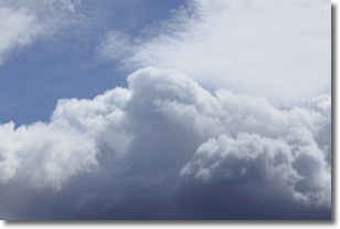
Weather Topic: What are Nimbostratus Clouds?
Home - Education - Cloud Types - Nimbostratus Clouds
 Next Topic: Precipitation
A nimbostratus cloud is similar to a stratus cloud in its formless,
smooth appearance. However, a nimbostratus cloud is darker than a stratus cloud,
because it is thicker.
Unlike a stratus cloud, a nimbostratus cloud typically brings with it the threat
of moderate to heavy precipitation. In some cases, the precipitation may evaporate
before reaching the ground, a phenomenon known as virga.
Next Topic: Precipitation
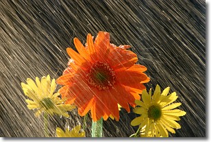
Weather Topic: What is Rain?
Home - Education - Precipitation - Rain
 Next Topic: Shelf Clouds
Precipitation in the form of water droplets is called rain.
Rain generally has a tendency to fall with less intensity over a greater period
of time, and when rainfall is more severe it is usually less sustained.
Rain is the most common form of precipitation and happens with greater frequency
depending on the season and regional influences. Cities have been shown to have
an observable effect on rainfall, due to an effect called the urban heat island.
Compared to upwind, monthly rainfall between twenty and forty miles downwind of
cities is 30% greater.
Next Topic: Shelf Clouds
Current conditions powered by WeatherAPI.com


