Weather Alert in New Mexico
Flash Flood Warning issued August 2 at 4:26PM MDT until August 2 at 7:30PM MDT by NWS El Paso Tx/Santa Teresa NM
AREAS AFFECTED: Grant, NM
DESCRIPTION: FFWEPZ The National Weather Service in El Paso Tx/Santa Teresa has issued a * Flash Flood Warning for... Central Grant County in southwestern New Mexico... * Until 730 PM MDT. * At 426 PM MDT, Doppler radar indicated slow moving thunderstorms around Santa Clara and Fort Bayard. Between 1 and 1.5 inches of rain have fallen over the Cameron Creek watershed just north of Santa Clara. Flash flooding is ongoing or expected to begin shortly. Low water crossings along Cameron Creek, including those in Santa Clara, will likely become inundated and too dangerous to cross. HAZARD...Flash flooding caused by thunderstorms. SOURCE...Radar. IMPACT...Flash flooding of small creeks and streams, as well as other poor drainage and low-lying areas. * Some locations that will experience flash flooding include... Shingle Canyon, Cobre, Bayard, Hanover, Fierro, Santa Clara and Fort Bayard.
INSTRUCTION: Turn around, don't drown when encountering flooded roads. Most flood deaths occur in vehicles. Remain alert for flooding even in locations not receiving rain. Arroyos, streams, and rivers can become raging killer currents in a matter of minutes, even from distant rainfall.
Want more detail? Get the Complete 7 Day and Night Detailed Forecast!
Current U.S. National Radar--Current
The Current National Weather Radar is shown below with a UTC Time (subtract 5 hours from UTC to get Eastern Time).

National Weather Forecast--Current
The Current National Weather Forecast and National Weather Map are shown below.

National Weather Forecast for Tomorrow
Tomorrow National Weather Forecast and Tomorrow National Weather Map are show below.

North America Water Vapor (Moisture)
This map shows recent moisture content over North America. Bright and colored areas show high moisture (ie, clouds); brown indicates very little moisture present; black indicates no moisture.

Weather Topic: What is Freezing Rain?
Home - Education - Precipitation - Freezing Rain
 Next Topic: Graupel
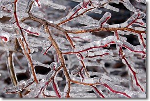
Freezing rain is a condition where precipitation which has fallen in the form of
water droplets reaches temperatures which are below freezing and freezes upon
coming into contact
with surface objects. The result of this precipitation is a glaze of ice which
can be damaging to plants and man-made structures. A severe onset of freezing
rain which results in a very thick glaze of ice is known as an ice storm.
Next Topic: Graupel
Weather Topic: What is Hail?
Home - Education - Precipitation - Hail
 Next Topic: Hole Punch Clouds
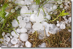
Hail is a form of precipitation which is recognized by large solid balls or
clumps of ice. Hail is created by thunderstorm clouds with strong updrafts of wind.
As the hailstones remain in the updraft, ice is deposited onto them until their
weight becomes heavy enough for them to fall to the earth's surface.
Hail storms can cause significant damage to crops, aircrafts, and man-made structures,
despite the fact that the duration is usually less than ten minutes.
Next Topic: Hole Punch Clouds
Current conditions powered by WeatherAPI.com


