Weather Alert in New York
Severe Thunderstorm Warning Special Weather Statement Wind Advisory
Special Weather Statement issued June 19 at 2:40PM EDT by NWS Burlington VT
AREAS AFFECTED: Eastern Clinton; Eastern Essex; Grand Isle; Western Franklin; Western Chittenden; Lamoille; Eastern Franklin; Eastern Chittenden
DESCRIPTION: At 240 PM EDT, Doppler radar was tracking a strong thunderstorm near Burlington, moving east at 35 mph. HAZARD...Wind gusts up to 40 mph. SOURCE...Radar indicated. IMPACT...Gusty winds could knock down tree limbs and blow around unsecured objects. Locations impacted include... Essex Junction, Burlington, South Burlington, Winooski, Cambridge Village, Westford, Colchester, Essex Junction Village, Fairfax, Underhill, Essex, Jericho Village, Underhill State Park, Fletcher, Milton, Cambridge, Jericho, South Hero, Fairfield, and Georgia. This includes Interstate 89 between mile markers 90 and 103.
INSTRUCTION: If outdoors, consider seeking shelter inside a building. If on or near Lake Champlain, get out of the water and move indoors or inside a vehicle. Remember, lightning can strike out to 10 miles from the parent thunderstorm. If you can hear thunder, you are close enough to be struck by lightning. Move to safe shelter now! Do not be caught on the water in a thunderstorm. A Severe Thunderstorm Watch remains in effect until 900 PM EDT for northern New York...and northwestern Vermont.
Want more detail? Get the Complete 7 Day and Night Detailed Forecast!
Current U.S. National Radar--Current
The Current National Weather Radar is shown below with a UTC Time (subtract 5 hours from UTC to get Eastern Time).

National Weather Forecast--Current
The Current National Weather Forecast and National Weather Map are shown below.

National Weather Forecast for Tomorrow
Tomorrow National Weather Forecast and Tomorrow National Weather Map are show below.

North America Water Vapor (Moisture)
This map shows recent moisture content over North America. Bright and colored areas show high moisture (ie, clouds); brown indicates very little moisture present; black indicates no moisture.

Weather Topic: What are Wall Clouds?
Home - Education - Cloud Types - Wall Clouds
 Next Topic: Altocumulus Clouds
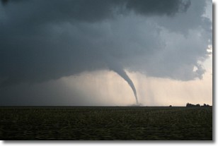
A wall cloud forms underneath the base of a cumulonimbus cloud,
and can be a hotbed for deadly tornadoes.
Wall clouds are formed by air flowing into the cumulonimbus clouds, which can
result in the wall cloud descending from the base of the cumulonimbus cloud, or
rising fractus clouds which join to the base of the storm cloud as the wall cloud
takes shape.
Wall clouds can be very large, and in the Northern Hemisphere they generally
form at the southern edge of cumulonimbus clouds.
Next Topic: Altocumulus Clouds
Weather Topic: What are Altostratus Clouds?
Home - Education - Cloud Types - Altostratus Clouds
 Next Topic: Cirrocumulus Clouds
Altostratus clouds form at mid to high-level altitudes
(between 2 and 7 km) and are created by a warm, stable air mass which causes
water vapor
to condense as it rise through the atmosphere. Usually altostratus clouds are
featureless sheets characterized by a uniform color.
In some cases, wind punching through the cloud formation may give it a waved
appearance, called altostratus undulatus. Altostratus clouds
are commonly seen with other cloud formations accompanying them.
Next Topic: Cirrocumulus Clouds
Current conditions powered by WeatherAPI.com


