Weather Alert in Michigan
Winter Storm Watch issued March 31 at 3:40PM EDT until April 2 at 8:00PM EDT by NWS Gaylord MI
AREAS AFFECTED: Western Chippewa; Central Chippewa; Southeast Chippewa; Western Mackinac; Eastern Mackinac; Mackinac Island/Bois Blanc Island
DESCRIPTION: * WHAT...Heavy mixed precipitation possible. Total snow and sleet accumulations between 2 and 4 inches and ice accumulations between one tenth and one quarter of an inch possible. Winds could gust 25 to 35 mph from the east. * WHERE...A portion of Eastern Upper Michigan. * WHEN...From late Wednesday night through Thursday evening. * IMPACTS...Plan on slippery road conditions. The hazardous conditions could impact the Thursday morning and evening commutes. * ADDITIONAL DETAILS...Precipitation is expected to start as snow early Thursday morning and continue through midday before transitioning to more sleet and freezing rain during the afternoon. Temperatures are expected to warm above freezing by Thursday evening.
INSTRUCTION: Monitor the latest forecasts for updates on this situation.
Want more detail? Get the Complete 7 Day and Night Detailed Forecast!
Current U.S. National Radar--Current
The Current National Weather Radar is shown below with a UTC Time (subtract 5 hours from UTC to get Eastern Time).

National Weather Forecast--Current
The Current National Weather Forecast and National Weather Map are shown below.

National Weather Forecast for Tomorrow
Tomorrow National Weather Forecast and Tomorrow National Weather Map are show below.

North America Water Vapor (Moisture)
This map shows recent moisture content over North America. Bright and colored areas show high moisture (ie, clouds); brown indicates very little moisture present; black indicates no moisture.

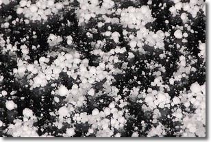
Weather Topic: What is Graupel?
Home - Education - Precipitation - Graupel
 Next Topic: Hail
Graupel is a form of precipitation that is created by atmospheric conditions
which cause supercooled water droplets to contact snow crystals and freeze to
their surface.
Sometimes known as soft hail or snow pellets, graupel is delicate and easily
destroyed by touch. Whereas hail usually falls during severe weather, graupel
doesn't require such conditions to form, and can form in mild precipitation
similar to situations which produce snowfall.
Next Topic: Hail
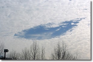
Weather Topic: What are Hole Punch Clouds?
Home - Education - Cloud Types - Hole Punch Clouds
 Next Topic: Mammatus Clouds
A hole punch cloud is an unusual occurrence when a disk-shaped
hole appears in a cirrostratus, cirrocumulus, or altocumulus cloud.
When part of the cloud forms ice crystals, water droplets in the surrounding area
of the cloud evaporate. The effect of this process produces a large elliptical
gap in the cloud. The hole punch cloud formation is rare, but it is not specific
to any geographic area.
Other names which have been used to describe this phenomena include fallstreak hole,
skypunch, and cloud hole.
Next Topic: Mammatus Clouds
Current conditions powered by WeatherAPI.com


