Weather Alert in California
Fire Weather Watch issued June 19 at 12:24PM PDT until June 22 at 11:00AM PDT by NWS Sacramento CA
AREAS AFFECTED: Northern Sacramento Valley to Southern Tehama County Line Below 1000 Ft; Central Sacramento Valley including Glenn/Colusa/Yuba/Northern Sutter/Butte County Below 1000 Ft; Southern Sacramento Valley In Yolo/Sacramento/Far Western Placer/Southern Sutter and Solano County Below 1000 Ft - Excludes the Delta; Eastern Delta; Northern San Joaquin Valley in San Joaquin and Stanislaus Counties Below 1000 ft - Excludes the Delta; Southern Motherlode From 1000 to 3000 Ft/Calaveras and Toulumne Counties; Southeast Edge Shasta/Trinity NF and Western Portions of Tehama/Glenn RU; Northern Sierra Foothills from 1000 to 3000 Ft. Includes Nevada-Yuba-Placer RU and Anador-Eldorado RU; Eastern Mendocino NF
DESCRIPTION: The National Weather Service in Sacramento has issued a Fire Weather Watch for gusty winds and low humidity, which is in effect from Saturday morning through Sunday morning. * Winds...North winds 15 to 25 mph with gusts up of 30 to 40 mph. Strongest winds expected across the Sacramento Valley along and west of Interstate 5, the Delta, and the northern San Joaquin Valley. * Humidity...Minimum daytime humidity: 15 to 25 percent. Overnight recoveries in the mid 40s to mid 50s. * Highest Threat...Sacramento Valley along and west of the I-5 corridor, adjacent Coastal Range, and the northern San Joaquin Valley. * Impacts...The combination of gusty winds and low humidity can cause fire to rapidly grow in size and intensity. Outdoor burning is not recommended.
INSTRUCTION: A Fire Weather Watch means that critical fire weather conditions are forecast to occur. Listen for later forecasts and possible Red Flag Warnings.
Want more detail? Get the Complete 7 Day and Night Detailed Forecast!
Current U.S. National Radar--Current
The Current National Weather Radar is shown below with a UTC Time (subtract 5 hours from UTC to get Eastern Time).

National Weather Forecast--Current
The Current National Weather Forecast and National Weather Map are shown below.

National Weather Forecast for Tomorrow
Tomorrow National Weather Forecast and Tomorrow National Weather Map are show below.

North America Water Vapor (Moisture)
This map shows recent moisture content over North America. Bright and colored areas show high moisture (ie, clouds); brown indicates very little moisture present; black indicates no moisture.

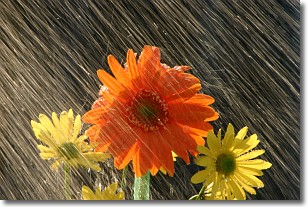
Weather Topic: What is Precipitation?
Home - Education - Precipitation - Precipitation
 Next Topic: Rain
Precipitation can refer to many different forms of water that
may fall from clouds. Precipitation occurs after a cloud has become saturated to
the point where its water particles are more dense than the air below the cloud.
In most cases, precipitation will reach the ground, but it is not uncommon for
precipitation to evaporate before it reaches the earth's surface.
When precipitation evaporates before it contacts the ground it is called Virga.
Graupel, hail, sleet, rain, drizzle, and snow are forms of precipitation, but fog
and mist are not considered precipitation because the water vapor which
constitutes them isn't dense enough to fall to the ground.
Next Topic: Rain
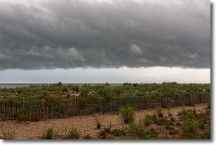
Weather Topic: What are Shelf Clouds?
Home - Education - Cloud Types - Shelf Clouds
 Next Topic: Sleet
A shelf cloud is similar to a wall cloud, but forms at the front
of a storm cloud, instead of at the rear, where wall clouds form.
A shelf cloud is caused by a series of events set into motion by the advancing
storm; first, cool air settles along the ground where precipitation has just fallen.
As the cool air is brought in, the warmer air is displaced, and rises above it,
because it is less dense. When the warmer air reaches the bottom of the storm cloud,
it begins to cool again, and the resulting condensation is a visible shelf cloud.
Next Topic: Sleet
Current conditions powered by WeatherAPI.com


