Weather Alert in North Carolina
Severe Thunderstorm Warning issued June 19 at 9:28PM EDT until June 19 at 10:15PM EDT by NWS Raleigh NC
AREAS AFFECTED: Edgecombe, NC; Johnston, NC; Nash, NC; Wayne, NC; Wilson, NC
DESCRIPTION: SVRRAH The National Weather Service in Raleigh has issued a * Severe Thunderstorm Warning for... Northeastern Wayne County in central North Carolina... Eastern Nash County in central North Carolina... Edgecombe County in central North Carolina... Wilson County in central North Carolina... East central Johnston County in central North Carolina... * Until 1015 PM EDT. * At 927 PM EDT, a severe thunderstorm was located 11 miles south of Bailey, or 12 miles northeast of Smithfield, moving east at 50 mph. HAZARD...60 mph wind gusts. SOURCE...Radar indicated. IMPACT...Expect damage to roofs, siding, and trees. * Locations impacted include... Rocky Mount, Tarboro, Nashville, Wilson, Elm City, Fremont, Dortches, Micro, Red Oak, and Princeville.
INSTRUCTION: Straight line winds can blow down trees, power lines, and damage mobile homes and other buildings. Seek shelter in a sturdy structure until the storm has passed. Stay away from windows as flying debris generated by damaging winds can be deadly. Large hail, damaging wind, and continuous cloud to ground lightning are occurring with this storm. Move indoors immediately. Lightning is one of nature's leading killers. Remember, if you can hear thunder, you are close enough to be struck by lightning.
Want more detail? Get the Complete 7 Day and Night Detailed Forecast!
Current U.S. National Radar--Current
The Current National Weather Radar is shown below with a UTC Time (subtract 5 hours from UTC to get Eastern Time).

National Weather Forecast--Current
The Current National Weather Forecast and National Weather Map are shown below.

National Weather Forecast for Tomorrow
Tomorrow National Weather Forecast and Tomorrow National Weather Map are show below.

North America Water Vapor (Moisture)
This map shows recent moisture content over North America. Bright and colored areas show high moisture (ie, clouds); brown indicates very little moisture present; black indicates no moisture.

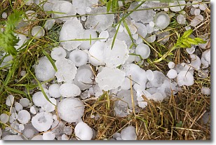
Weather Topic: What is Hail?
Home - Education - Precipitation - Hail
 Next Topic: Hole Punch Clouds
Hail is a form of precipitation which is recognized by large solid balls or
clumps of ice. Hail is created by thunderstorm clouds with strong updrafts of wind.
As the hailstones remain in the updraft, ice is deposited onto them until their
weight becomes heavy enough for them to fall to the earth's surface.
Hail storms can cause significant damage to crops, aircrafts, and man-made structures,
despite the fact that the duration is usually less than ten minutes.
Next Topic: Hole Punch Clouds
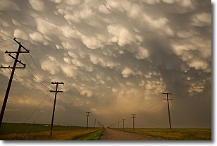
Weather Topic: What are Mammatus Clouds?
Home - Education - Cloud Types - Mammatus Clouds
 Next Topic: Nimbostratus Clouds
A mammatus cloud is a cloud with a unique feature which resembles
a web of pouches hanging along the base of the cloud.
In the United States, mammatus clouds tend to form in the warmer months, commonly
in the Midwest and eastern regions.
While they usually form at the bottom of a cumulonimbis cloud, they can also form
under altostratus, altocumulus, stratocumulus, and cirrus clouds. Mammatus clouds
warn that severe weather is close.
Next Topic: Nimbostratus Clouds
Current conditions powered by WeatherAPI.com


