Weather Alert in New York
Flood Warning issued March 31 at 10:42PM EDT until April 1 at 7:00PM EDT by NWS Buffalo NY
AREAS AFFECTED: Monroe, NY
DESCRIPTION: * WHAT...Flooding caused by excessive rainfall continues along Irondequoit Creek. * WHERE...A portion of western New York, including the following county, Monroe. * WHEN...Until 700 PM EDT Wednesday. * IMPACTS...Flooding of low-lying and flood-prone locations along Irondequoit Creek is imminent or occurring. Widespread flooding will continue in Ellison Park, and flooding may also impact Panorama Plaza and portions of Blossom Road. * ADDITIONAL DETAILS... - At 1037 PM EDT, gauge reports indicated heavy rain due to thunderstorms with Irondequoit Creek approaching 9.5 feet. The creek will continue to rise overnight, and may approach the flood of record at 10 feet which occurred in July 1998. - Some locations that will experience flooding include... areas along Irondequoit Creek in Irondequoit, East Rochester, Fairport, Brighton and Penfield. - http://www.weather.gov/safety/flood
INSTRUCTION: Turn around, don't drown when encountering flooded roads. Most flood deaths occur in vehicles.
Want more detail? Get the Complete 7 Day and Night Detailed Forecast!
Current U.S. National Radar--Current
The Current National Weather Radar is shown below with a UTC Time (subtract 5 hours from UTC to get Eastern Time).

National Weather Forecast--Current
The Current National Weather Forecast and National Weather Map are shown below.

National Weather Forecast for Tomorrow
Tomorrow National Weather Forecast and Tomorrow National Weather Map are show below.

North America Water Vapor (Moisture)
This map shows recent moisture content over North America. Bright and colored areas show high moisture (ie, clouds); brown indicates very little moisture present; black indicates no moisture.

Weather Topic: What are Altostratus Clouds?
Home - Education - Cloud Types - Altostratus Clouds
 Next Topic: Cirrocumulus Clouds
Altostratus clouds form at mid to high-level altitudes
(between 2 and 7 km) and are created by a warm, stable air mass which causes
water vapor
to condense as it rise through the atmosphere. Usually altostratus clouds are
featureless sheets characterized by a uniform color.
In some cases, wind punching through the cloud formation may give it a waved
appearance, called altostratus undulatus. Altostratus clouds
are commonly seen with other cloud formations accompanying them.
Next Topic: Cirrocumulus Clouds
Weather Topic: What are Cirrostratus Clouds?
Home - Education - Cloud Types - Cirrostratus Clouds
 Next Topic: Cirrus Clouds
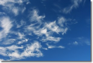
Cirrostratus clouds are high, thin clouds that form above
20,000 feet and are made mostly of ice crystals. They sometimes look like giant
feathers, horse tails, or curls of hair in the sky.
These clouds are pushed by the jet stream and can move at high speeds reaching
100 mph.
What do they indicate?
They indicate that a precipitation is likely within 24 hours.
Next Topic: Cirrus Clouds
Current conditions powered by WeatherAPI.com


