Weather Alert in Ohio
Severe Thunderstorm Warning issued April 29 at 4:29PM EDT until April 29 at 5:15PM EDT by NWS Cleveland OH
AREAS AFFECTED: Cuyahoga, OH; Geauga, OH; Mahoning, OH; Portage, OH; Stark, OH; Summit, OH; Trumbull, OH
DESCRIPTION: SVRCLE The National Weather Service in Cleveland has issued a * Severe Thunderstorm Warning for... Trumbull County in northeastern Ohio... Mahoning County in northeastern Ohio... Portage County in northeastern Ohio... Southern Geauga County in northeastern Ohio... Southeastern Cuyahoga County in northeastern Ohio... Stark County in northeastern Ohio... Summit County in northeastern Ohio... * Until 515 PM EDT. * At 429 PM EDT, severe thunderstorms were located along a line extending from 6 miles northwest of Cuyahoga Falls to near Waynesburg, moving northeast at 50 mph. HAZARD...60 mph wind gusts and penny size hail. SOURCE...Radar indicated. IMPACT...Expect damage to trees and power lines. * Locations impacted include... Akron, Canton, Youngstown, Warren, Salem, Ravenna, Columbiana, Cuyahoga Falls, Boardman, North Royalton, Kent, Barberton, Green, Solon, Alliance, Hudson, Niles, Twinsburg, Tallmadge, and North Canton.
INSTRUCTION: For your protection move to an interior room on the lowest floor of a building.
Want more detail? Get the Complete 7 Day and Night Detailed Forecast!
Current U.S. National Radar--Current
The Current National Weather Radar is shown below with a UTC Time (subtract 5 hours from UTC to get Eastern Time).

National Weather Forecast--Current
The Current National Weather Forecast and National Weather Map are shown below.

National Weather Forecast for Tomorrow
Tomorrow National Weather Forecast and Tomorrow National Weather Map are show below.

North America Water Vapor (Moisture)
This map shows recent moisture content over North America. Bright and colored areas show high moisture (ie, clouds); brown indicates very little moisture present; black indicates no moisture.

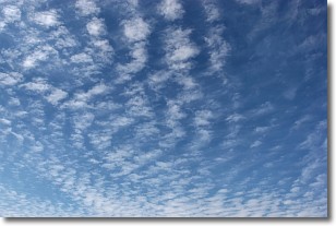
Weather Topic: What are Cirrocumulus Clouds?
Home - Education - Cloud Types - Cirrocumulus Clouds
 Next Topic: Cirrostratus Clouds
Cirrocumulus clouds form at high altitudes (usually around 5 km)
and have distinguishing characteristics displayed in a fine layer of
small cloud patches. These small cloud patches are sometimes referred to as
"cloudlets" in relation to the whole cloud formation.
Cirrocumulus clouds are formed from ice crystals and water droplets. Often, the
water droplets in the cloud freeze into ice crystals and the cloud becomes a
cirrostratus cloud. Because of this common occurrence, cirrocumulus cloud
formations generally pass rapidly.
Next Topic: Cirrostratus Clouds
Weather Topic: What are Cirrus Clouds?
Home - Education - Cloud Types - Cirrus Clouds
 Next Topic: Condensation
Cirrus clouds are high-level clouds that occur above 20,000 feet
and are composed mainly of ice crystals.
They are thin and wispy in appearance.
What do they indicate?
They are often the first sign of an approaching storm.
Next Topic: Condensation
Current conditions powered by WeatherAPI.com


