Weather Alert in California
Red Flag Warning issued June 18 at 12:38PM PDT until June 21 at 12:00AM PDT by NWS Reno NV
AREAS AFFECTED: Southern Mono County; Eastern Lassen County; Northern Sierra Front - Carson City/Douglas/Storey/Southern Washoe/Eastern Lyon/Far Southern Lassen Counties; Southern Sierra Front - Alpine/Northern Mono/Southern Lyon/Western Mineral Counties; West Humboldt Basin - Pershing County; Lahontan Basin - Churchill and Eastern Mineral Counties; Northern Washoe County
DESCRIPTION: The National Weather Service in Reno has issued a Red Flag Warning for gusty winds and low humidity, which is in effect from 1 PM Thursday to midnight PDT Friday night. The Fire Weather Watch is no longer in effect. * CHANGES... * Affected Area...Fire Weather Zone 274 Southern Mono County, Fire Weather Zone 278 Eastern Lassen County, Fire Weather Zone 420 Northern Sierra Front including Carson City, Douglas, Storey, Southern Washoe, Western Lyon, and Far Southern Lassen Counties, Fire Weather Zone 421 Southern Sierra Front including Alpine, Northern Mono, Southern Lyon, and Western Mineral Counties, Fire Weather Zone 423 West Humboldt Basin in Pershing County, Fire Weather Zone 429 Lahontan Basin including Churchill and Eastern Mineral Counties and Fire Weather Zone 458 Northern Washoe County. * Winds...For Thursday, southwest to west 15-25 mph gusting to 30-40 mph. For Friday, southwest to west 20-25 mph gusting to 40-45 mph. Wind prone areas Friday may reach 50-60 mph. * Humidity...For Thursday, minimum humidity 8-15% in the afternoon. For Friday, minimum humidity 5-15% in the afternoon. Limited overnight recoveries Friday morning of 20- 30%. * Duration...For Thursday, 5 to 7 hours. For Friday, 6 to 9 hours. * Impacts...The combination of gusty winds and low humidity can cause fire to rapidly grow in size and intensity before first responders can contain them.
INSTRUCTION: Avoid outdoor activities that can cause a spark near dry vegetation, such as yard work, target shooting, or campfires. Follow local fire restrictions. Check weather.gov/reno for updates and livingwithfire.info for preparedness tips.
Want more detail? Get the Complete 7 Day and Night Detailed Forecast!
Current U.S. National Radar--Current
The Current National Weather Radar is shown below with a UTC Time (subtract 5 hours from UTC to get Eastern Time).

National Weather Forecast--Current
The Current National Weather Forecast and National Weather Map are shown below.

National Weather Forecast for Tomorrow
Tomorrow National Weather Forecast and Tomorrow National Weather Map are show below.

North America Water Vapor (Moisture)
This map shows recent moisture content over North America. Bright and colored areas show high moisture (ie, clouds); brown indicates very little moisture present; black indicates no moisture.

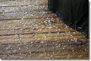
Weather Topic: What is Sleet?
Home - Education - Precipitation - Sleet
 Next Topic: Snow
Sleet is a form of precipitation in which small ice pellets are the primary
components. These ice pellets are smaller and more translucent than hailstones,
and harder than graupel. Sleet is caused by specific atmospheric conditions and
therefore typically doesn't last for extended periods of time.
The condition which leads to sleet formation requires a warmer body of air to be
wedged in between two sub-freezing bodies of air. When snow falls through a warmer
layer of air it melts, and as it falls through the next sub-freezing body of air
it freezes again, forming ice pellets known as sleet. In some cases, water
droplets don't have time to freeze before reaching the surface and the result is
freezing rain.
Next Topic: Snow
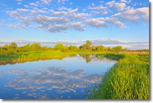
Weather Topic: What are Stratocumulus Clouds?
Home - Education - Cloud Types - Stratocumulus Clouds
 Next Topic: Stratus Clouds
Stratocumulus clouds are similar to altocumulus clouds in their
fluffy appearance, but have a slightly darker shade due to their additional mass.
A good way to distinguish the two cloud types is to hold your hand out and measure
the size of an individual cloud; if it is the size of your thumb it is generally
an altocumulus cloud, if it is the size of your hand it is generally a
stratocumulus cloud.
It is uncommon for stratocumulus clouds to produce precipitation, but if they do
it is usually a light rain or snow.
Next Topic: Stratus Clouds
Current conditions powered by WeatherAPI.com


