Weather Alert in New York
Flood Warning issued April 1 at 12:26AM EDT until April 1 at 9:15AM EDT by NWS Binghamton NY
AREAS AFFECTED: Cayuga, NY
DESCRIPTION: * WHAT...Flooding caused by excessive rainfall has caused the Owasco Inlet at Moravia to surpass major flood stage of 9.5 feet and the gauge is currently reading water levels around 10.5 feet. * WHERE...The Owasco Inlet at Moravia in Cayuga County. * WHEN...Until 915 AM EDT Wednesday. * IMPACTS...Several roads are currently flooded and closed in the vicinity of the Owasco Inlet at Moravia. * ADDITIONAL DETAILS... - At 1216 AM EDT, Over 3 inches of rain fell across the area today and flooding is ongoing in the warned area. - Rainfall has ended and flood waters will continue to recede through the overnight hours. - Some locations that will experience flooding include... Locke, Moravia, Cascade and Fillmore Glen State Park. - https://www.weather.gov/safety/flood
INSTRUCTION: Turn around, don't drown when encountering flooded roads. Most flood deaths occur in vehicles.
Want more detail? Get the Complete 7 Day and Night Detailed Forecast!
Current U.S. National Radar--Current
The Current National Weather Radar is shown below with a UTC Time (subtract 5 hours from UTC to get Eastern Time).

National Weather Forecast--Current
The Current National Weather Forecast and National Weather Map are shown below.

National Weather Forecast for Tomorrow
Tomorrow National Weather Forecast and Tomorrow National Weather Map are show below.

North America Water Vapor (Moisture)
This map shows recent moisture content over North America. Bright and colored areas show high moisture (ie, clouds); brown indicates very little moisture present; black indicates no moisture.

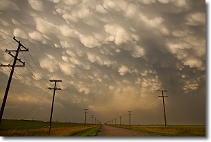
Weather Topic: What are Mammatus Clouds?
Home - Education - Cloud Types - Mammatus Clouds
 Next Topic: Nimbostratus Clouds
A mammatus cloud is a cloud with a unique feature which resembles
a web of pouches hanging along the base of the cloud.
In the United States, mammatus clouds tend to form in the warmer months, commonly
in the Midwest and eastern regions.
While they usually form at the bottom of a cumulonimbis cloud, they can also form
under altostratus, altocumulus, stratocumulus, and cirrus clouds. Mammatus clouds
warn that severe weather is close.
Next Topic: Nimbostratus Clouds
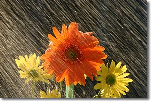
Weather Topic: What is Precipitation?
Home - Education - Precipitation - Precipitation
 Next Topic: Rain
Precipitation can refer to many different forms of water that
may fall from clouds. Precipitation occurs after a cloud has become saturated to
the point where its water particles are more dense than the air below the cloud.
In most cases, precipitation will reach the ground, but it is not uncommon for
precipitation to evaporate before it reaches the earth's surface.
When precipitation evaporates before it contacts the ground it is called Virga.
Graupel, hail, sleet, rain, drizzle, and snow are forms of precipitation, but fog
and mist are not considered precipitation because the water vapor which
constitutes them isn't dense enough to fall to the ground.
Next Topic: Rain
Current conditions powered by WeatherAPI.com


