Weather Alert in Colorado
Fire Weather Watch issued August 3 at 1:18PM MDT until August 5 at 8:00PM MDT by NWS Grand Junction CO
AREAS AFFECTED: Little Snake; Routt; White River; Lower Colorado River; Paradox Valley; North Fork; Eastern Uintah Basin; Book Cliffs
DESCRIPTION: The National Weather Service in Grand Junction has issued a Red Flag Warning for gusty winds, low relative humidity and dry fuels, which is in effect from 11 AM to 9 PM MDT Monday. A Fire Weather Watch has also been issued. This Fire Weather Watch for gusty winds, low relative humidity and dry fuels is in effect from Tuesday morning through Tuesday evening. The Fire Weather Watch is no longer in effect. * AFFECTED AREA...In Colorado, Fire Weather Zone 200 Little Snake Forecast Area, Fire Weather Zone 201 Routt Forecast Area, Fire Weather Zone 202 White River Forecast Area, Fire Weather Zone 203 Lower Colorado River, Fire Weather Zone 290 Paradox Valley Forecast Area and Fire Weather Zone 292 North Fork Forecast Area. In Utah, Fire Weather Zone 486 Eastern Uinta Basin and Fire Weather Zone 487 Book Cliffs. * TIMING...For the Red Flag Warning, from 11 AM to 9 PM MDT Monday. For the Fire Weather Watch, from Tuesday morning through Tuesday evening. * WINDS...Southwest 10 to 20 mph with gusts up to 30 mph. * RELATIVE HUMIDITY...5 to 10 percent. * IMPACTS...Any fire that develops will catch and spread quickly. Outdoor burning is not recommended.
INSTRUCTION: A Red Flag Warning means that critical fire weather conditions are either occurring now, or will shortly. A combination of strong winds, low relative humidity, and warm temperatures can contribute to extreme fire behavior. A Fire Weather Watch means that critical fire weather conditions are forecast to occur. Listen for later forecasts and possible Red Flag Warnings.
Want more detail? Get the Complete 7 Day and Night Detailed Forecast!
Current U.S. National Radar--Current
The Current National Weather Radar is shown below with a UTC Time (subtract 5 hours from UTC to get Eastern Time).

National Weather Forecast--Current
The Current National Weather Forecast and National Weather Map are shown below.

National Weather Forecast for Tomorrow
Tomorrow National Weather Forecast and Tomorrow National Weather Map are show below.

North America Water Vapor (Moisture)
This map shows recent moisture content over North America. Bright and colored areas show high moisture (ie, clouds); brown indicates very little moisture present; black indicates no moisture.

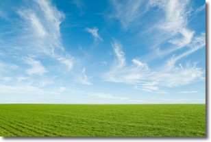
Weather Topic: What are Cirrus Clouds?
Home - Education - Cloud Types - Cirrus Clouds
 Next Topic: Condensation
Cirrus clouds are high-level clouds that occur above 20,000 feet
and are composed mainly of ice crystals.
They are thin and wispy in appearance.
What do they indicate?
They are often the first sign of an approaching storm.
Next Topic: Condensation
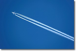
Weather Topic: What are Contrails?
Home - Education - Cloud Types - Contrails
 Next Topic: Cumulonimbus Clouds
A contrail is an artificial cloud, created by the passing of an
aircraft.
Contrails form because water vapor in the exhaust of aircraft engines is suspended
in the air under certain temperatures and humidity conditions. These contrails
are called exhaust contrails.
Another type of contrail can form due to a temporary reduction in air pressure
moving over the plane's surface, causing condensation.
These are called aerodynamic contrails.
When you can see your breath on a cold day, it is also because of condensation.
The reason contrails last longer than the condensation from your breath is
because the water in contrails freezes into ice particles.
Next Topic: Cumulonimbus Clouds
Current conditions powered by WeatherAPI.com


