Weather Alert in Ohio
Severe Thunderstorm Warning issued April 29 at 4:37PM EDT until April 29 at 5:00PM EDT by NWS Pittsburgh PA
AREAS AFFECTED: Belmont, OH; Carroll, OH; Columbiana, OH; Harrison, OH; Jefferson, OH; Allegheny, PA; Beaver, PA; Lawrence, PA; Washington, PA; Brooke, WV; Hancock, WV; Marshall, WV; Ohio, WV
DESCRIPTION: At 437 PM EDT, severe thunderstorms were located along a line extending from near Lisbon to near Wellsville to near Wintersville to St. Clairsville, moving east at 70 mph. THESE ARE DESTRUCTIVE STORMS FOR Hancock and Brooke Counties. HAZARD...80 mph wind gusts. SOURCE...Radar indicated. IMPACT...Extensive tree damage and widespread power outages. Mobile homes will be heavily damaged. Expect considerable damage to roofs, windows and vehicles. Locations impacted include... Wheeling, Weirton, Steubenville, Salem, East Liverpool, Aliquippa, Beaver Falls, Martins Ferry, Columbiana, Monaca, St. Clairsville, East Palestine, Bellaire, Wellsville, Warwood, Wellsburg, Bethlehem, West Liberty, Triadelphia, and Avella.
INSTRUCTION: For your protection move to an interior room on the lowest floor of a building. Please report severe weather by calling 412-262-1988, posting to the NWS Pittsburgh Facebook page, or using X @NWSPITTSBURGH.
Want more detail? Get the Complete 7 Day and Night Detailed Forecast!
Current U.S. National Radar--Current
The Current National Weather Radar is shown below with a UTC Time (subtract 5 hours from UTC to get Eastern Time).

National Weather Forecast--Current
The Current National Weather Forecast and National Weather Map are shown below.

National Weather Forecast for Tomorrow
Tomorrow National Weather Forecast and Tomorrow National Weather Map are show below.

North America Water Vapor (Moisture)
This map shows recent moisture content over North America. Bright and colored areas show high moisture (ie, clouds); brown indicates very little moisture present; black indicates no moisture.

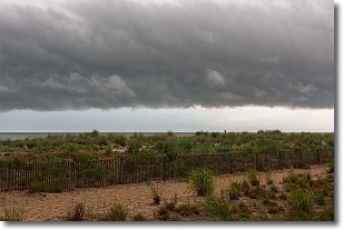
Weather Topic: What are Shelf Clouds?
Home - Education - Cloud Types - Shelf Clouds
 Next Topic: Sleet
A shelf cloud is similar to a wall cloud, but forms at the front
of a storm cloud, instead of at the rear, where wall clouds form.
A shelf cloud is caused by a series of events set into motion by the advancing
storm; first, cool air settles along the ground where precipitation has just fallen.
As the cool air is brought in, the warmer air is displaced, and rises above it,
because it is less dense. When the warmer air reaches the bottom of the storm cloud,
it begins to cool again, and the resulting condensation is a visible shelf cloud.
Next Topic: Sleet
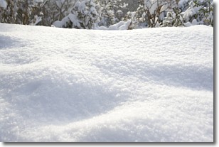
Weather Topic: What is Snow?
Home - Education - Precipitation - Snow
 Next Topic: Stratocumulus Clouds
Snow is precipitation taking the form of ice crystals. Each ice crystal, or snowflake,
has unique characteristics, but all of them grow in a hexagonal structure.
Snowfall can last for sustained periods of time and result in significant buildup
of snow on the ground.
On the earth's surface, snow starts out light and powdery, but as it begins to melt
it tends to become more granular, producing small bits of ice which have the consistency of
sand. After several cycles of melting and freezing, snow can become very dense
and ice-like, commonly known as snow pack.
Next Topic: Stratocumulus Clouds
Current conditions powered by WeatherAPI.com


