Weather Alert in Pennsylvania
Severe Thunderstorm Warning issued June 19 at 6:49PM EDT until June 19 at 7:45PM EDT by NWS State College PA
AREAS AFFECTED: Lycoming, PA; Sullivan, PA
DESCRIPTION: SVRCTP The National Weather Service in State College PA has issued a * Severe Thunderstorm Warning for... Central Lycoming County in north central Pennsylvania... Sullivan County in north central Pennsylvania... * Until 745 PM EDT. * At 648 PM EDT, severe thunderstorms were located along a line extending from Buttonwood to Trout Run to Loyalsockville to Williamsport, moving east northeast at 45 mph. HAZARD...70 mph wind gusts and penny size hail. SOURCE...Radar indicated. IMPACT...Expect considerable tree damage. Damage is likely to mobile homes, roofs, and outbuildings. * Locations impacted include... Williamsport, Montoursville, Duboistown, Kettle Creek Gorge, Cogan Station, Ricketts Glen State Park, Ralston, Muncy Valley, Trout Run, Lincoln Falls, Barbours, and Shunk. This includes Interstate 180 from mile markers 16 to 29.
INSTRUCTION: These are dangerous storms. To stay safe, immediately move inside a well built structure and stay away from windows.
Want more detail? Get the Complete 7 Day and Night Detailed Forecast!
Current U.S. National Radar--Current
The Current National Weather Radar is shown below with a UTC Time (subtract 5 hours from UTC to get Eastern Time).

National Weather Forecast--Current
The Current National Weather Forecast and National Weather Map are shown below.

National Weather Forecast for Tomorrow
Tomorrow National Weather Forecast and Tomorrow National Weather Map are show below.

North America Water Vapor (Moisture)
This map shows recent moisture content over North America. Bright and colored areas show high moisture (ie, clouds); brown indicates very little moisture present; black indicates no moisture.

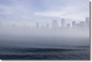
Weather Topic: What is Fog?
Home - Education - Cloud Types - Fog
 Next Topic: Fractus Clouds
Fog is technically a type of stratus cloud, which lies along the
ground and obscures visibility.
It is usually created when humidity in the air condenses into tiny water droplets.
Because of this, some places are more prone to foggy weather, such as regions
close to a body of water.
Fog is similar to mist; both are the appearance of water droplets suspended in
the air, but fog is the term applied to the condition when visibility is less than 1 km.
Next Topic: Fractus Clouds
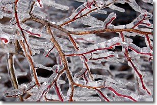
Weather Topic: What is Freezing Rain?
Home - Education - Precipitation - Freezing Rain
 Next Topic: Graupel
Freezing rain is a condition where precipitation which has fallen in the form of
water droplets reaches temperatures which are below freezing and freezes upon
coming into contact
with surface objects. The result of this precipitation is a glaze of ice which
can be damaging to plants and man-made structures. A severe onset of freezing
rain which results in a very thick glaze of ice is known as an ice storm.
Next Topic: Graupel
Current conditions powered by WeatherAPI.com


