Weather Alert in Pennsylvania
Severe Thunderstorm Warning issued June 19 at 6:44PM EDT until June 19 at 7:15PM EDT by NWS State College PA
AREAS AFFECTED: Bedford, PA; Blair, PA
DESCRIPTION: SVRCTP The National Weather Service in State College PA has issued a * Severe Thunderstorm Warning for... Northern Bedford County in south central Pennsylvania... Southern Blair County in central Pennsylvania... * Until 715 PM EDT. * At 643 PM EDT, severe thunderstorms were located along a line extending from Duncansville to Central City, moving east at 45 mph. HAZARD...60 mph wind gusts. SOURCE...Radar indicated. IMPACT...Expect damage to roofs, siding, and trees. * Locations impacted include... Hollidaysburg, Bedford, Breezewood, Roaring Spring, New Enterprise, Martinsburg, Everett, Claysburg, Duncansville, Osterburg, St. Clairsville, and Blue Knob State Park. This includes the following Interstates... Interstate 70 from mile markers 147 to 148. The Pennsylvania Turnpike between mile markers 142 and 148, between mile markers 153 and 157, and from mile markers 161 to 163. Interstate 99 from mile markers 0 to 28.
INSTRUCTION: Stay inside a well built structure and keep away from windows.
Want more detail? Get the Complete 7 Day and Night Detailed Forecast!
Current U.S. National Radar--Current
The Current National Weather Radar is shown below with a UTC Time (subtract 5 hours from UTC to get Eastern Time).

National Weather Forecast--Current
The Current National Weather Forecast and National Weather Map are shown below.

National Weather Forecast for Tomorrow
Tomorrow National Weather Forecast and Tomorrow National Weather Map are show below.

North America Water Vapor (Moisture)
This map shows recent moisture content over North America. Bright and colored areas show high moisture (ie, clouds); brown indicates very little moisture present; black indicates no moisture.

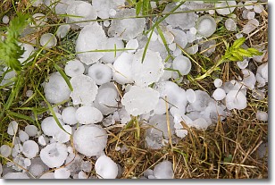
Weather Topic: What is Hail?
Home - Education - Precipitation - Hail
 Next Topic: Hole Punch Clouds
Hail is a form of precipitation which is recognized by large solid balls or
clumps of ice. Hail is created by thunderstorm clouds with strong updrafts of wind.
As the hailstones remain in the updraft, ice is deposited onto them until their
weight becomes heavy enough for them to fall to the earth's surface.
Hail storms can cause significant damage to crops, aircrafts, and man-made structures,
despite the fact that the duration is usually less than ten minutes.
Next Topic: Hole Punch Clouds
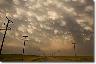
Weather Topic: What are Mammatus Clouds?
Home - Education - Cloud Types - Mammatus Clouds
 Next Topic: Nimbostratus Clouds
A mammatus cloud is a cloud with a unique feature which resembles
a web of pouches hanging along the base of the cloud.
In the United States, mammatus clouds tend to form in the warmer months, commonly
in the Midwest and eastern regions.
While they usually form at the bottom of a cumulonimbis cloud, they can also form
under altostratus, altocumulus, stratocumulus, and cirrus clouds. Mammatus clouds
warn that severe weather is close.
Next Topic: Nimbostratus Clouds
Current conditions powered by WeatherAPI.com


