Weather Alert in Montana
Winter Storm Watch issued March 31 at 10:34AM MDT until April 3 at 6:00AM MDT by NWS Missoula MT
AREAS AFFECTED: Bitterroot/Sapphire Mountains; Butte/Blackfoot Region; Potomac/Seeley Lake Region
DESCRIPTION: * WHAT...Heavy snow possible. There is a chance of moderate to major winter weather impacts. Total snow accumulations between 6 and 12 inches possible for terrain above 5500 feet, including MacDonald Pass, Homestake Pass, Lost Trail Pass and Lolo Pass. 2 to 6 inches possible down to 3000 feet, including Butte, Seeley Lake and Anaconda. Winds could gust as high as 35 mph. * WHERE...Butte, Highway 12 Garrison to Elliston, I-90 East Missoula to Bearmouth, Georgetown Lake, Highway 93 Sula to Lost Trail Pass, Highway 83 Seeley Lake to Condon, Lolo Pass, MacDonald Pass, Homestake Pass, and Highway 200 Bonner to Greenough. * WHEN...From Thursday morning through late Thursday night. * IMPACTS...For MODERATE winter weather impacts, expect disruptions to normal activities. Hazardous traveling conditions. Use extra caution while driving. Closures and disruptions to infrastructure may occur. For MAJOR winter weather impacts, expect considerable disruptions to normal activities. Dangerous or impossible traveling conditions. Avoid travel in the impacted areas if possible. Widespread closures and disruptions to infrastructure may occur. The hazardous conditions could impact the Thursday morning and evening commutes, especially over higher passes. * ADDITIONAL DETAILS...Heavy, wet snow may cause power outages and tree damage.
INSTRUCTION: Monitor the latest forecasts for updates on this situation.
Want more detail? Get the Complete 7 Day and Night Detailed Forecast!
Current U.S. National Radar--Current
The Current National Weather Radar is shown below with a UTC Time (subtract 5 hours from UTC to get Eastern Time).

National Weather Forecast--Current
The Current National Weather Forecast and National Weather Map are shown below.

National Weather Forecast for Tomorrow
Tomorrow National Weather Forecast and Tomorrow National Weather Map are show below.

North America Water Vapor (Moisture)
This map shows recent moisture content over North America. Bright and colored areas show high moisture (ie, clouds); brown indicates very little moisture present; black indicates no moisture.

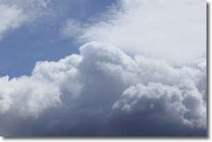
Weather Topic: What are Nimbostratus Clouds?
Home - Education - Cloud Types - Nimbostratus Clouds
 Next Topic: Precipitation
A nimbostratus cloud is similar to a stratus cloud in its formless,
smooth appearance. However, a nimbostratus cloud is darker than a stratus cloud,
because it is thicker.
Unlike a stratus cloud, a nimbostratus cloud typically brings with it the threat
of moderate to heavy precipitation. In some cases, the precipitation may evaporate
before reaching the ground, a phenomenon known as virga.
Next Topic: Precipitation
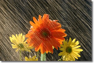
Weather Topic: What is Rain?
Home - Education - Precipitation - Rain
 Next Topic: Shelf Clouds
Precipitation in the form of water droplets is called rain.
Rain generally has a tendency to fall with less intensity over a greater period
of time, and when rainfall is more severe it is usually less sustained.
Rain is the most common form of precipitation and happens with greater frequency
depending on the season and regional influences. Cities have been shown to have
an observable effect on rainfall, due to an effect called the urban heat island.
Compared to upwind, monthly rainfall between twenty and forty miles downwind of
cities is 30% greater.
Next Topic: Shelf Clouds
Current conditions powered by WeatherAPI.com


