Weather Alert in Idaho
Winter Storm Watch issued March 31 at 10:34AM MDT until April 3 at 6:00AM MDT by NWS Missoula MT
AREAS AFFECTED: Southern Clearwater Mountains
DESCRIPTION: * WHAT...Heavy snow possible. There is a chance of moderate to major winter weather impacts. Total snow accumulations of 5 to 11 inches possible above 4000 feet, including Lolo Pass, Dixie and Elk City. 2 to 5 inches possible below 4000 feet. * WHERE...Dixie, Elk City, and Highway 12 Lowell to Lolo Pass. * WHEN...From Wednesday evening through late Thursday night. * IMPACTS...For MODERATE winter weather impacts, expect disruptions to normal activities. Hazardous traveling conditions. Use extra caution while driving. Closures and disruptions to infrastructure may occur. For MAJOR winter weather impacts, expect considerable disruptions to normal activities. Dangerous or impossible traveling conditions. Avoid travel in the impacted areas if possible. Widespread closures and disruptions to infrastructure may occur. The hazardous conditions could impact the Thursday morning and evening commutes, especially over higher passes. * ADDITIONAL DETAILS...Heavy, wet snow may cause power outages and tree damage.
INSTRUCTION: Monitor the latest forecasts for updates on this situation.
Want more detail? Get the Complete 7 Day and Night Detailed Forecast!
Current U.S. National Radar--Current
The Current National Weather Radar is shown below with a UTC Time (subtract 5 hours from UTC to get Eastern Time).

National Weather Forecast--Current
The Current National Weather Forecast and National Weather Map are shown below.

National Weather Forecast for Tomorrow
Tomorrow National Weather Forecast and Tomorrow National Weather Map are show below.

North America Water Vapor (Moisture)
This map shows recent moisture content over North America. Bright and colored areas show high moisture (ie, clouds); brown indicates very little moisture present; black indicates no moisture.

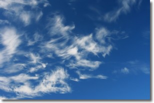
Weather Topic: What are Cirrostratus Clouds?
Home - Education - Cloud Types - Cirrostratus Clouds
 Next Topic: Cirrus Clouds
Cirrostratus clouds are high, thin clouds that form above
20,000 feet and are made mostly of ice crystals. They sometimes look like giant
feathers, horse tails, or curls of hair in the sky.
These clouds are pushed by the jet stream and can move at high speeds reaching
100 mph.
What do they indicate?
They indicate that a precipitation is likely within 24 hours.
Next Topic: Cirrus Clouds
Weather Topic: What is Condensation?
Home - Education - Precipitation - Condensation
 Next Topic: Contrails
Condensation is the process which creates clouds, and therefore
it is a crucial process in the water cycle.
Condensation is the change of matter from a state of gas into a state of liquid,
and it happens because water molecules release heat into the atmosphere and
become organized into a more closely packed structure, what we might see as
water droplets.
Water is always present in the air around us as a vapor, but it's too small for
us to see. When water undergoes the process of condensation it becomes organized
into visible water droplets. You've probably seen condensation happen before on the
surface of a cold drink!
Next Topic: Contrails
Current conditions powered by WeatherAPI.com


