Weather Alert in Idaho
Winter Storm Watch issued March 31 at 10:34AM MDT until April 3 at 6:00AM MDT by NWS Missoula MT
AREAS AFFECTED: Southern Clearwater Mountains
DESCRIPTION: * WHAT...Heavy snow possible. There is a chance of moderate to major winter weather impacts. Total snow accumulations of 5 to 11 inches possible above 4000 feet, including Lolo Pass, Dixie and Elk City. 2 to 5 inches possible below 4000 feet. * WHERE...Dixie, Elk City, and Highway 12 Lowell to Lolo Pass. * WHEN...From Wednesday evening through late Thursday night. * IMPACTS...For MODERATE winter weather impacts, expect disruptions to normal activities. Hazardous traveling conditions. Use extra caution while driving. Closures and disruptions to infrastructure may occur. For MAJOR winter weather impacts, expect considerable disruptions to normal activities. Dangerous or impossible traveling conditions. Avoid travel in the impacted areas if possible. Widespread closures and disruptions to infrastructure may occur. The hazardous conditions could impact the Thursday morning and evening commutes, especially over higher passes. * ADDITIONAL DETAILS...Heavy, wet snow may cause power outages and tree damage.
INSTRUCTION: Monitor the latest forecasts for updates on this situation.
Want more detail? Get the Complete 7 Day and Night Detailed Forecast!
Current U.S. National Radar--Current
The Current National Weather Radar is shown below with a UTC Time (subtract 5 hours from UTC to get Eastern Time).

National Weather Forecast--Current
The Current National Weather Forecast and National Weather Map are shown below.

National Weather Forecast for Tomorrow
Tomorrow National Weather Forecast and Tomorrow National Weather Map are show below.

North America Water Vapor (Moisture)
This map shows recent moisture content over North America. Bright and colored areas show high moisture (ie, clouds); brown indicates very little moisture present; black indicates no moisture.

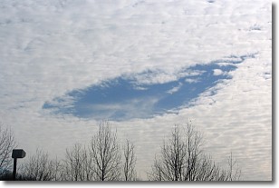
Weather Topic: What are Hole Punch Clouds?
Home - Education - Cloud Types - Hole Punch Clouds
 Next Topic: Mammatus Clouds
A hole punch cloud is an unusual occurrence when a disk-shaped
hole appears in a cirrostratus, cirrocumulus, or altocumulus cloud.
When part of the cloud forms ice crystals, water droplets in the surrounding area
of the cloud evaporate. The effect of this process produces a large elliptical
gap in the cloud. The hole punch cloud formation is rare, but it is not specific
to any geographic area.
Other names which have been used to describe this phenomena include fallstreak hole,
skypunch, and cloud hole.
Next Topic: Mammatus Clouds
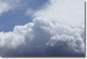
Weather Topic: What are Nimbostratus Clouds?
Home - Education - Cloud Types - Nimbostratus Clouds
 Next Topic: Precipitation
A nimbostratus cloud is similar to a stratus cloud in its formless,
smooth appearance. However, a nimbostratus cloud is darker than a stratus cloud,
because it is thicker.
Unlike a stratus cloud, a nimbostratus cloud typically brings with it the threat
of moderate to heavy precipitation. In some cases, the precipitation may evaporate
before reaching the ground, a phenomenon known as virga.
Next Topic: Precipitation
Current conditions powered by WeatherAPI.com


