Weather Alert in Ohio
Severe Thunderstorm Warning issued April 29 at 4:46PM EDT until April 29 at 5:30PM EDT by NWS Pittsburgh PA
AREAS AFFECTED: Columbiana, OH; Allegheny, PA; Armstrong, PA; Beaver, PA; Butler, PA; Indiana, PA; Lawrence, PA; Washington, PA; Westmoreland, PA; Brooke, WV; Hancock, WV; Ohio, WV
DESCRIPTION: SVRPBZ The National Weather Service in Pittsburgh has issued a * Severe Thunderstorm Warning for... Eastern Columbiana County in east central Ohio... Beaver County in western Pennsylvania... Northern Washington County in southwestern Pennsylvania... Southeastern Lawrence County in western Pennsylvania... Butler County in west central Pennsylvania... Southwestern Indiana County in west central Pennsylvania... Allegheny County in southwestern Pennsylvania... Northwestern Westmoreland County in southwestern Pennsylvania... Armstrong County in west central Pennsylvania... Ohio County in northern West Virginia... Brooke County in northern West Virginia... Hancock County in northern West Virginia... * Until 530 PM EDT. * At 445 PM EDT, severe thunderstorms were located along a line extending from Lisbon to near Shippingport to near Avella to West Liberty, moving east at 75 mph. THESE ARE DESTRUCTIVE STORMS FOR southern Beaver, northern Washington, and Allegheny Counties. HAZARD...80 mph wind gusts. SOURCE...Radar indicated. IMPACT...Extensive tree damage and widespread power outages. Mobile homes will be heavily damaged. Expect considerable damage to roofs, windows and vehicles. * Locations impacted include... Pittsburgh, Penn Hills, Mount Lebanon, Bethel Park, Ross Township, McCandless Township, Monroeville, Cranberry, Moon Township, McMurray, Greensburg, Weirton, McKeesport, Butler, Washington, Franklin Park, Jeannette, Aliquippa, Canonsburg, and Beaver Falls. This includes the following highways... Interstate 70 in Pennsylvania between mile markers 15 and 22. Pennsylvania Turnpike between mile markers 9 and 75. Interstate 79 in Pennsylvania between mile markers 34 and 105. Interstate 80 in Pennsylvania near mile marker 44. Parkway North between mile markers 1 and 13. Interstate 376 in Pennsylvania between mile markers 25 and 84.
INSTRUCTION: For your protection move to an interior room on the lowest floor of a building. Please report severe weather by calling 412-262-1988, posting to the NWS Pittsburgh Facebook page, or using X @NWSPITTSBURGH.
Want more detail? Get the Complete 7 Day and Night Detailed Forecast!
Current U.S. National Radar--Current
The Current National Weather Radar is shown below with a UTC Time (subtract 5 hours from UTC to get Eastern Time).

National Weather Forecast--Current
The Current National Weather Forecast and National Weather Map are shown below.

National Weather Forecast for Tomorrow
Tomorrow National Weather Forecast and Tomorrow National Weather Map are show below.

North America Water Vapor (Moisture)
This map shows recent moisture content over North America. Bright and colored areas show high moisture (ie, clouds); brown indicates very little moisture present; black indicates no moisture.

Weather Topic: What is Freezing Rain?
Home - Education - Precipitation - Freezing Rain
 Next Topic: Graupel
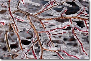
Freezing rain is a condition where precipitation which has fallen in the form of
water droplets reaches temperatures which are below freezing and freezes upon
coming into contact
with surface objects. The result of this precipitation is a glaze of ice which
can be damaging to plants and man-made structures. A severe onset of freezing
rain which results in a very thick glaze of ice is known as an ice storm.
Next Topic: Graupel
Weather Topic: What is Hail?
Home - Education - Precipitation - Hail
 Next Topic: Hole Punch Clouds
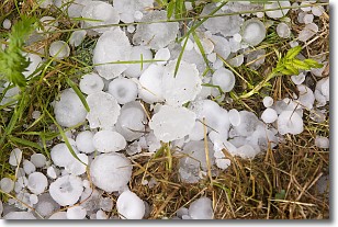
Hail is a form of precipitation which is recognized by large solid balls or
clumps of ice. Hail is created by thunderstorm clouds with strong updrafts of wind.
As the hailstones remain in the updraft, ice is deposited onto them until their
weight becomes heavy enough for them to fall to the earth's surface.
Hail storms can cause significant damage to crops, aircrafts, and man-made structures,
despite the fact that the duration is usually less than ten minutes.
Next Topic: Hole Punch Clouds
Current conditions powered by WeatherAPI.com


