Weather Alert in Ohio
Severe Thunderstorm Warning issued April 29 at 4:46PM EDT until April 29 at 5:30PM EDT by NWS Pittsburgh PA
AREAS AFFECTED: Columbiana, OH; Allegheny, PA; Armstrong, PA; Beaver, PA; Butler, PA; Indiana, PA; Lawrence, PA; Washington, PA; Westmoreland, PA; Brooke, WV; Hancock, WV; Ohio, WV
DESCRIPTION: SVRPBZ The National Weather Service in Pittsburgh has issued a * Severe Thunderstorm Warning for... Eastern Columbiana County in east central Ohio... Beaver County in western Pennsylvania... Northern Washington County in southwestern Pennsylvania... Southeastern Lawrence County in western Pennsylvania... Butler County in west central Pennsylvania... Southwestern Indiana County in west central Pennsylvania... Allegheny County in southwestern Pennsylvania... Northwestern Westmoreland County in southwestern Pennsylvania... Armstrong County in west central Pennsylvania... Ohio County in northern West Virginia... Brooke County in northern West Virginia... Hancock County in northern West Virginia... * Until 530 PM EDT. * At 445 PM EDT, severe thunderstorms were located along a line extending from Lisbon to near Shippingport to near Avella to West Liberty, moving east at 75 mph. THESE ARE DESTRUCTIVE STORMS FOR southern Beaver, northern Washington, and Allegheny Counties. HAZARD...80 mph wind gusts. SOURCE...Radar indicated. IMPACT...Extensive tree damage and widespread power outages. Mobile homes will be heavily damaged. Expect considerable damage to roofs, windows and vehicles. * Locations impacted include... Pittsburgh, Penn Hills, Mount Lebanon, Bethel Park, Ross Township, McCandless Township, Monroeville, Cranberry, Moon Township, McMurray, Greensburg, Weirton, McKeesport, Butler, Washington, Franklin Park, Jeannette, Aliquippa, Canonsburg, and Beaver Falls. This includes the following highways... Interstate 70 in Pennsylvania between mile markers 15 and 22. Pennsylvania Turnpike between mile markers 9 and 75. Interstate 79 in Pennsylvania between mile markers 34 and 105. Interstate 80 in Pennsylvania near mile marker 44. Parkway North between mile markers 1 and 13. Interstate 376 in Pennsylvania between mile markers 25 and 84.
INSTRUCTION: For your protection move to an interior room on the lowest floor of a building. Please report severe weather by calling 412-262-1988, posting to the NWS Pittsburgh Facebook page, or using X @NWSPITTSBURGH.
Want more detail? Get the Complete 7 Day and Night Detailed Forecast!
Current U.S. National Radar--Current
The Current National Weather Radar is shown below with a UTC Time (subtract 5 hours from UTC to get Eastern Time).

National Weather Forecast--Current
The Current National Weather Forecast and National Weather Map are shown below.

National Weather Forecast for Tomorrow
Tomorrow National Weather Forecast and Tomorrow National Weather Map are show below.

North America Water Vapor (Moisture)
This map shows recent moisture content over North America. Bright and colored areas show high moisture (ie, clouds); brown indicates very little moisture present; black indicates no moisture.

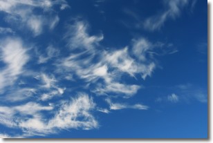
Weather Topic: What are Cirrostratus Clouds?
Home - Education - Cloud Types - Cirrostratus Clouds
 Next Topic: Cirrus Clouds
Cirrostratus clouds are high, thin clouds that form above
20,000 feet and are made mostly of ice crystals. They sometimes look like giant
feathers, horse tails, or curls of hair in the sky.
These clouds are pushed by the jet stream and can move at high speeds reaching
100 mph.
What do they indicate?
They indicate that a precipitation is likely within 24 hours.
Next Topic: Cirrus Clouds
Weather Topic: What is Condensation?
Home - Education - Precipitation - Condensation
 Next Topic: Contrails
Condensation is the process which creates clouds, and therefore
it is a crucial process in the water cycle.
Condensation is the change of matter from a state of gas into a state of liquid,
and it happens because water molecules release heat into the atmosphere and
become organized into a more closely packed structure, what we might see as
water droplets.
Water is always present in the air around us as a vapor, but it's too small for
us to see. When water undergoes the process of condensation it becomes organized
into visible water droplets. You've probably seen condensation happen before on the
surface of a cold drink!
Next Topic: Contrails
Current conditions powered by WeatherAPI.com


