Weather Alert in Texas
Flood Warning issued April 29 at 8:41AM CDT until May 4 at 7:43AM CDT by NWS Norman OK
AREAS AFFECTED: Clay, TX; Wichita, TX
DESCRIPTION: ...The National Weather Service in Norman OK has issued a Flood Warning for the following rivers in Texas... Wichita River at Wichita Falls affecting Clay and Wichita Counties. * WHAT...Major flooding is forecast. * WHERE...Wichita River at Wichita Falls. * WHEN...From Wednesday morning to Sunday morning. * IMPACTS...At 22.0 feet, In Wichita Falls... extensive flooding occurs in Harrell and Lucy Parks. Flooding occurs in homes north of Third Street and in Tanglewood Hollow... and in Scotland Park. Flood depths up to 2 feet occur in an area north of Sixth Street and east of Scott Avenue. Agricultural areas upstream and downstream from Wichita Falls experience widespread flood depths up to 4 feet. * ADDITIONAL DETAILS... - At 7:45 AM CDT Tuesday the stage was 10.4 feet. - Bankfull stage is 18.0 feet. - Forecast...The river will fall to 9.8 feet this afternoon. The river is expected to rise above flood stage tomorrow morning to 22.5 feet tomorrow evening. - Flood stage is 18.0 feet. - Flood History...This crest compares to a previous crest of 22.7 feet on 06/04/1941. - http://www.weather.gov/safety/flood
INSTRUCTION: Stay tuned to further developments by listening to your local radio, television, or NOAA Weather Radio for further information. Turn around, don't drown when encountering flooded roads. Most flood deaths occur in vehicles. Additional information is available at www.weather.gov.
Want more detail? Get the Complete 7 Day and Night Detailed Forecast!
Current U.S. National Radar--Current
The Current National Weather Radar is shown below with a UTC Time (subtract 5 hours from UTC to get Eastern Time).

National Weather Forecast--Current
The Current National Weather Forecast and National Weather Map are shown below.

National Weather Forecast for Tomorrow
Tomorrow National Weather Forecast and Tomorrow National Weather Map are show below.

North America Water Vapor (Moisture)
This map shows recent moisture content over North America. Bright and colored areas show high moisture (ie, clouds); brown indicates very little moisture present; black indicates no moisture.

Weather Topic: What are Nimbostratus Clouds?
Home - Education - Cloud Types - Nimbostratus Clouds
 Next Topic: Precipitation
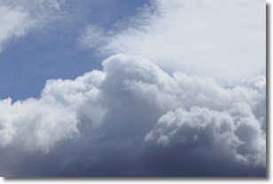
A nimbostratus cloud is similar to a stratus cloud in its formless,
smooth appearance. However, a nimbostratus cloud is darker than a stratus cloud,
because it is thicker.
Unlike a stratus cloud, a nimbostratus cloud typically brings with it the threat
of moderate to heavy precipitation. In some cases, the precipitation may evaporate
before reaching the ground, a phenomenon known as virga.
Next Topic: Precipitation
Weather Topic: What is Rain?
Home - Education - Precipitation - Rain
 Next Topic: Shelf Clouds
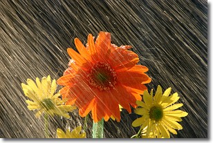
Precipitation in the form of water droplets is called rain.
Rain generally has a tendency to fall with less intensity over a greater period
of time, and when rainfall is more severe it is usually less sustained.
Rain is the most common form of precipitation and happens with greater frequency
depending on the season and regional influences. Cities have been shown to have
an observable effect on rainfall, due to an effect called the urban heat island.
Compared to upwind, monthly rainfall between twenty and forty miles downwind of
cities is 30% greater.
Next Topic: Shelf Clouds
Current conditions powered by WeatherAPI.com


