Weather Alert in North Carolina
Beach Hazards Statement issued August 3 at 4:16AM EDT until August 3 at 8:00PM EDT by NWS Newport/Morehead City NC
AREAS AFFECTED: Hatteras Island
DESCRIPTION: * WHAT...For the High Surf Advisory, large breaking waves of 4 to 9 feet in the surf zone. For the Beach Hazards Statement, dangerous rip currents, large breaking waves expected, and strong longshore currents in the surf zone. For the Coastal Flood Advisory, 1 to 2 feet of inundation above ground level expected in low-lying areas near shorelines and tidal waterways. * WHERE....For the High Surf advisory, the beaches north of Cape Hatteras. For the Beach Hazards Statement, all Hatteras Island beaches. For the Coastal Flood Advisory, oceanside areas of Hatteras Island. * WHEN...For the High Surf Advisory, until midnight EDT tonight. For the Beach Hazards Statement, through this evening. For the Coastal Flood Advisory, from 2 PM this afternoon to 8 PM EDT this evening. * IMPACTS...A Coastal Flood Advisory indicates that onshore winds and tides will combine to generate flooding of low areas along the shore. Dangerous swimming and surfing conditions and localized beach erosion. Rip currents can sweep even the best swimmers away from shore into deeper water. Dangerous shore break can throw a swimmer or surfer head first into the bottom causing neck and back injuries. Strong longshore currents will create dangerous swimming conditions. * ADDITIONAL DETAILS...The most likely time for strong rip currents to occur is a couple hours either side of low tide, which will occur around 9:00 AM this morning..
INSTRUCTION: If travel is required, allow extra time as some roads may be closed. Do not drive around barricades or through water of unknown depth. Take the necessary actions to protect flood-prone property. Inexperienced swimmers should remain out of the water due to dangerous surf conditions, such as life-threatening rip currents, shore break and strong longshore currents.
Want more detail? Get the Complete 7 Day and Night Detailed Forecast!
Current U.S. National Radar--Current
The Current National Weather Radar is shown below with a UTC Time (subtract 5 hours from UTC to get Eastern Time).

National Weather Forecast--Current
The Current National Weather Forecast and National Weather Map are shown below.

National Weather Forecast for Tomorrow
Tomorrow National Weather Forecast and Tomorrow National Weather Map are show below.

North America Water Vapor (Moisture)
This map shows recent moisture content over North America. Bright and colored areas show high moisture (ie, clouds); brown indicates very little moisture present; black indicates no moisture.

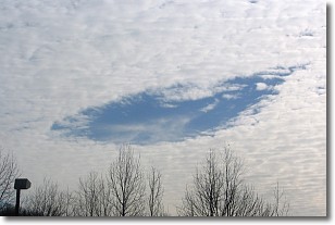
Weather Topic: What are Hole Punch Clouds?
Home - Education - Cloud Types - Hole Punch Clouds
 Next Topic: Mammatus Clouds
A hole punch cloud is an unusual occurrence when a disk-shaped
hole appears in a cirrostratus, cirrocumulus, or altocumulus cloud.
When part of the cloud forms ice crystals, water droplets in the surrounding area
of the cloud evaporate. The effect of this process produces a large elliptical
gap in the cloud. The hole punch cloud formation is rare, but it is not specific
to any geographic area.
Other names which have been used to describe this phenomena include fallstreak hole,
skypunch, and cloud hole.
Next Topic: Mammatus Clouds
Weather Topic: What are Nimbostratus Clouds?
Home - Education - Cloud Types - Nimbostratus Clouds
 Next Topic: Precipitation
A nimbostratus cloud is similar to a stratus cloud in its formless,
smooth appearance. However, a nimbostratus cloud is darker than a stratus cloud,
because it is thicker.
Unlike a stratus cloud, a nimbostratus cloud typically brings with it the threat
of moderate to heavy precipitation. In some cases, the precipitation may evaporate
before reaching the ground, a phenomenon known as virga.
Next Topic: Precipitation
Current conditions powered by WeatherAPI.com


