Weather Alert in California
Wind Advisory issued June 19 at 3:02PM PDT until June 20 at 11:00PM PDT by NWS Reno NV
AREAS AFFECTED: Mono; Mineral and Southern Lyon Counties; Greater Reno-Carson City-Minden Area; Western Nevada Basin and Range including Pyramid Lake
DESCRIPTION: * WHAT...For the Lake Wind Advisory for Pyramid Lake, both Lahontan and Rye Patch reservoirs, Walker Lake, Topaz Lake, Bridgeport Reservoir, Mono Lake, Crowley Lake, and Washoe Lake, west winds 20 to 25 mph with gusts up to 45 mph. Wave heights on Pyramid lake 1 to 2 feet. For the Wind Advisory, southwest to west winds 20 to 30 mph with gusts up to 45 mph. Wind prone locations could see wind gusts up to 50 to 60 mph. * WHERE...In California, Mono County. In Nevada, Western Nevada Basin and Range including Pyramid Lake, Greater Reno-Carson City-Minden Area, and Mineral and Southern Lyon Counties. * WHEN...For the Lake Wind Advisory, until 9 PM PDT this evening. For the Wind Advisory, from 11 AM to 11 PM PDT Friday. * IMPACTS...Gusty winds will blow around unsecured objects. Tree limbs could be blown down and a few power outages may result. Small boats, kayaks and paddle boards will be prone to capsizing and should remain off lake waters until conditions improve. * ADDITIONAL DETAILS...Blowing dust will be possible over and downstream from dry lake beds such as the Carson Sink and Black Rock Desert. Within blowing dust, expect reduced visibility down to 1 quarter mile.
INSTRUCTION: Now is the time to secure loose outdoor items such as patio furniture, holiday decorations, and trash cans before winds increase which could blow these items away. The best thing to do is prepare ahead of time by making sure you have extra food and water on hand, flashlights with spare batteries and/or candles in the event of a power outage. Check lake conditions before heading out and be prepared for a sudden increase in winds and wave heights. Consider postponing boating activities on the lake until a day with less wind.
Want more detail? Get the Complete 7 Day and Night Detailed Forecast!
Current U.S. National Radar--Current
The Current National Weather Radar is shown below with a UTC Time (subtract 5 hours from UTC to get Eastern Time).

National Weather Forecast--Current
The Current National Weather Forecast and National Weather Map are shown below.

National Weather Forecast for Tomorrow
Tomorrow National Weather Forecast and Tomorrow National Weather Map are show below.

North America Water Vapor (Moisture)
This map shows recent moisture content over North America. Bright and colored areas show high moisture (ie, clouds); brown indicates very little moisture present; black indicates no moisture.

Weather Topic: What are Hole Punch Clouds?
Home - Education - Cloud Types - Hole Punch Clouds
 Next Topic: Mammatus Clouds
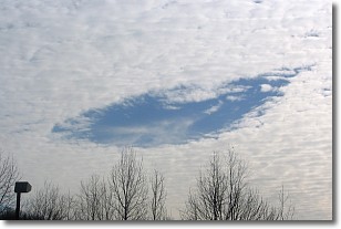
A hole punch cloud is an unusual occurrence when a disk-shaped
hole appears in a cirrostratus, cirrocumulus, or altocumulus cloud.
When part of the cloud forms ice crystals, water droplets in the surrounding area
of the cloud evaporate. The effect of this process produces a large elliptical
gap in the cloud. The hole punch cloud formation is rare, but it is not specific
to any geographic area.
Other names which have been used to describe this phenomena include fallstreak hole,
skypunch, and cloud hole.
Next Topic: Mammatus Clouds
Weather Topic: What are Nimbostratus Clouds?
Home - Education - Cloud Types - Nimbostratus Clouds
 Next Topic: Precipitation
A nimbostratus cloud is similar to a stratus cloud in its formless,
smooth appearance. However, a nimbostratus cloud is darker than a stratus cloud,
because it is thicker.
Unlike a stratus cloud, a nimbostratus cloud typically brings with it the threat
of moderate to heavy precipitation. In some cases, the precipitation may evaporate
before reaching the ground, a phenomenon known as virga.
Next Topic: Precipitation
Current conditions powered by WeatherAPI.com


