Weather Alert in California
Wind Advisory issued June 18 at 12:38PM PDT until June 20 at 11:00PM PDT by NWS Reno NV
AREAS AFFECTED: Mono; Mineral and Southern Lyon Counties; Greater Reno-Carson City-Minden Area; Western Nevada Basin and Range including Pyramid Lake
DESCRIPTION: * WHAT...For the Lake Wind Advisory for Pyramid Lake, both Lahontan and Rye Patch reservoirs, Walker Lake, Topaz Lake, Bridgeport Reservoir, Mono Lake, Crowley Lake, and Washoe Lake, west winds 20 to 25 mph with gusts up to 45 mph. Wave heights on Pyramid lake 1 to 2 feet. For the Wind Advisory, southwest to west winds 20 to 30 mph with gusts up to 45 mph. Wind prone locations could see wind gusts up to 50 to 60 mph. * WHERE...In California, Mono County. In Nevada, Western Nevada Basin and Range including Pyramid Lake, Greater Reno-Carson City-Minden Area, and Mineral and Southern Lyon Counties. * WHEN...For the Lake Wind Advisory, from 1 PM to 9 PM PDT Thursday. For the Wind Advisory, from 11 AM to 11 PM PDT Friday. * IMPACTS...Gusty winds will blow around unsecured objects. Tree limbs could be blown down and a few power outages may result. Small boats, kayaks and paddle boards will be prone to capsizing and should remain off lake waters until conditions improve. * ADDITIONAL DETAILS...Blowing dust will be possible over and downstream from dry lake beds such as the Carson Sink and Black Rock Desert. Within blowing dust, expect reduced visibility down to 1 quarter mile.
INSTRUCTION: Now is the time to secure loose outdoor items such as patio furniture, holiday decorations, and trash cans before winds increase which could blow these items away. The best thing to do is prepare ahead of time by making sure you have extra food and water on hand, flashlights with spare batteries and/or candles in the event of a power outage. Check lake conditions before heading out and be prepared for a sudden increase in winds and wave heights. Consider postponing boating activities on the lake until a day with less wind.
Want more detail? Get the Complete 7 Day and Night Detailed Forecast!
Current U.S. National Radar--Current
The Current National Weather Radar is shown below with a UTC Time (subtract 5 hours from UTC to get Eastern Time).

National Weather Forecast--Current
The Current National Weather Forecast and National Weather Map are shown below.

National Weather Forecast for Tomorrow
Tomorrow National Weather Forecast and Tomorrow National Weather Map are show below.

North America Water Vapor (Moisture)
This map shows recent moisture content over North America. Bright and colored areas show high moisture (ie, clouds); brown indicates very little moisture present; black indicates no moisture.

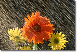
Weather Topic: What is Precipitation?
Home - Education - Precipitation - Precipitation
 Next Topic: Rain
Precipitation can refer to many different forms of water that
may fall from clouds. Precipitation occurs after a cloud has become saturated to
the point where its water particles are more dense than the air below the cloud.
In most cases, precipitation will reach the ground, but it is not uncommon for
precipitation to evaporate before it reaches the earth's surface.
When precipitation evaporates before it contacts the ground it is called Virga.
Graupel, hail, sleet, rain, drizzle, and snow are forms of precipitation, but fog
and mist are not considered precipitation because the water vapor which
constitutes them isn't dense enough to fall to the ground.
Next Topic: Rain
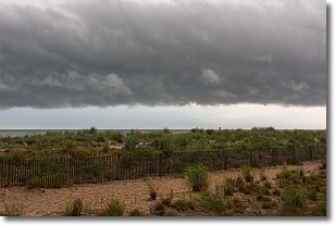
Weather Topic: What are Shelf Clouds?
Home - Education - Cloud Types - Shelf Clouds
 Next Topic: Sleet
A shelf cloud is similar to a wall cloud, but forms at the front
of a storm cloud, instead of at the rear, where wall clouds form.
A shelf cloud is caused by a series of events set into motion by the advancing
storm; first, cool air settles along the ground where precipitation has just fallen.
As the cool air is brought in, the warmer air is displaced, and rises above it,
because it is less dense. When the warmer air reaches the bottom of the storm cloud,
it begins to cool again, and the resulting condensation is a visible shelf cloud.
Next Topic: Sleet
Current conditions powered by WeatherAPI.com


