Weather Alert in California
Lake Wind Advisory issued June 18 at 12:38PM PDT until June 19 at 9:00PM PDT by NWS Reno NV
AREAS AFFECTED: Mono; Mineral and Southern Lyon Counties; Greater Reno-Carson City-Minden Area; Western Nevada Basin and Range including Pyramid Lake
DESCRIPTION: * WHAT...For the Lake Wind Advisory for Pyramid Lake, both Lahontan and Rye Patch reservoirs, Walker Lake, Topaz Lake, Bridgeport Reservoir, Mono Lake, Crowley Lake, and Washoe Lake, west winds 20 to 25 mph with gusts up to 45 mph. Wave heights on Pyramid lake 1 to 2 feet. For the Wind Advisory, southwest to west winds 20 to 30 mph with gusts up to 45 mph. Wind prone locations could see wind gusts up to 50 to 60 mph. * WHERE...In California, Mono County. In Nevada, Western Nevada Basin and Range including Pyramid Lake, Greater Reno-Carson City-Minden Area, and Mineral and Southern Lyon Counties. * WHEN...For the Lake Wind Advisory, from 1 PM to 9 PM PDT Thursday. For the Wind Advisory, from 11 AM to 11 PM PDT Friday. * IMPACTS...Gusty winds will blow around unsecured objects. Tree limbs could be blown down and a few power outages may result. Small boats, kayaks and paddle boards will be prone to capsizing and should remain off lake waters until conditions improve. * ADDITIONAL DETAILS...Blowing dust will be possible over and downstream from dry lake beds such as the Carson Sink and Black Rock Desert. Within blowing dust, expect reduced visibility down to 1 quarter mile.
INSTRUCTION: Now is the time to secure loose outdoor items such as patio furniture, holiday decorations, and trash cans before winds increase which could blow these items away. The best thing to do is prepare ahead of time by making sure you have extra food and water on hand, flashlights with spare batteries and/or candles in the event of a power outage. Check lake conditions before heading out and be prepared for a sudden increase in winds and wave heights. Consider postponing boating activities on the lake until a day with less wind.
Want more detail? Get the Complete 7 Day and Night Detailed Forecast!
Current U.S. National Radar--Current
The Current National Weather Radar is shown below with a UTC Time (subtract 5 hours from UTC to get Eastern Time).

National Weather Forecast--Current
The Current National Weather Forecast and National Weather Map are shown below.

National Weather Forecast for Tomorrow
Tomorrow National Weather Forecast and Tomorrow National Weather Map are show below.

North America Water Vapor (Moisture)
This map shows recent moisture content over North America. Bright and colored areas show high moisture (ie, clouds); brown indicates very little moisture present; black indicates no moisture.

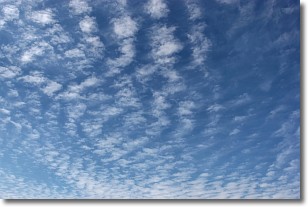
Weather Topic: What are Cirrocumulus Clouds?
Home - Education - Cloud Types - Cirrocumulus Clouds
 Next Topic: Cirrostratus Clouds
Cirrocumulus clouds form at high altitudes (usually around 5 km)
and have distinguishing characteristics displayed in a fine layer of
small cloud patches. These small cloud patches are sometimes referred to as
"cloudlets" in relation to the whole cloud formation.
Cirrocumulus clouds are formed from ice crystals and water droplets. Often, the
water droplets in the cloud freeze into ice crystals and the cloud becomes a
cirrostratus cloud. Because of this common occurrence, cirrocumulus cloud
formations generally pass rapidly.
Next Topic: Cirrostratus Clouds
Weather Topic: What are Cirrus Clouds?
Home - Education - Cloud Types - Cirrus Clouds
 Next Topic: Condensation
Cirrus clouds are high-level clouds that occur above 20,000 feet
and are composed mainly of ice crystals.
They are thin and wispy in appearance.
What do they indicate?
They are often the first sign of an approaching storm.
Next Topic: Condensation
Current conditions powered by WeatherAPI.com


