Weather Alert in Minnesota
Winter Storm Watch issued April 1 at 8:53PM CDT until April 4 at 7:00PM CDT by NWS Aberdeen SD
AREAS AFFECTED: Traverse; Brown; Marshall; Roberts; Day
DESCRIPTION: * WHAT...For the Winter Weather Advisory, mixed precipitation and patchy blowing snow. Additional snow accumulations between 2 and 4 inches and ice accumulations around a light glaze. Winds gusting as high as 35 mph. For the Winter Storm Watch, heavy mixed precipitation and patchy blowing snow possible. Total snow and sleet accumulations between 6 and 9 inches and ice accumulations around one tenth of an inch possible. Winds could gust as high as 35 mph. * WHERE...In Minnesota, Traverse County. In South Dakota, Brown, Day, Marshall, and Roberts Counties. * WHEN...For the Winter Weather Advisory, until 7 PM CDT Thursday. For the Winter Storm Watch, from Friday morning through Saturday evening. * IMPACTS...Travel could be very difficult. The combination of falling snow and winds may lead to periods of blowing snow that may briefly reduce visibility. The hazardous conditions could impact the Thursday morning and evening commutes.
INSTRUCTION: Slow down and use caution while traveling. In Minnesota, the latest road conditions can be obtained at 511mn.org, or by calling 5 1 1. In South Dakota, the latest road conditions can be obtained by calling 5 1 1. Monitor the latest forecasts for updates on this situation.
Want more detail? Get the Complete 7 Day and Night Detailed Forecast!
Current U.S. National Radar--Current
The Current National Weather Radar is shown below with a UTC Time (subtract 5 hours from UTC to get Eastern Time).

National Weather Forecast--Current
The Current National Weather Forecast and National Weather Map are shown below.

National Weather Forecast for Tomorrow
Tomorrow National Weather Forecast and Tomorrow National Weather Map are show below.

North America Water Vapor (Moisture)
This map shows recent moisture content over North America. Bright and colored areas show high moisture (ie, clouds); brown indicates very little moisture present; black indicates no moisture.

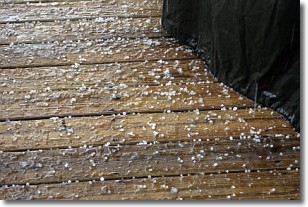
Weather Topic: What is Sleet?
Home - Education - Precipitation - Sleet
 Next Topic: Snow
Sleet is a form of precipitation in which small ice pellets are the primary
components. These ice pellets are smaller and more translucent than hailstones,
and harder than graupel. Sleet is caused by specific atmospheric conditions and
therefore typically doesn't last for extended periods of time.
The condition which leads to sleet formation requires a warmer body of air to be
wedged in between two sub-freezing bodies of air. When snow falls through a warmer
layer of air it melts, and as it falls through the next sub-freezing body of air
it freezes again, forming ice pellets known as sleet. In some cases, water
droplets don't have time to freeze before reaching the surface and the result is
freezing rain.
Next Topic: Snow
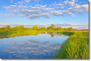
Weather Topic: What are Stratocumulus Clouds?
Home - Education - Cloud Types - Stratocumulus Clouds
 Next Topic: Stratus Clouds
Stratocumulus clouds are similar to altocumulus clouds in their
fluffy appearance, but have a slightly darker shade due to their additional mass.
A good way to distinguish the two cloud types is to hold your hand out and measure
the size of an individual cloud; if it is the size of your thumb it is generally
an altocumulus cloud, if it is the size of your hand it is generally a
stratocumulus cloud.
It is uncommon for stratocumulus clouds to produce precipitation, but if they do
it is usually a light rain or snow.
Next Topic: Stratus Clouds
Current conditions powered by WeatherAPI.com


