Weather Alert in North Carolina
Special Weather Statement issued June 19 at 9:43PM EDT by NWS Wakefield VA
AREAS AFFECTED: Hertford; Gates; Pasquotank; Camden; Western Currituck; Bertie; Chowan; Perquimans; Eastern Currituck; Chesapeake; Virginia Beach
DESCRIPTION: At 942 PM EDT, Doppler radar was tracking strong thunderstorms along a line extending from near South Mills to near Belvidere to near Windsor. Movement was east at 40 mph. HAZARD...Wind gusts up to 40 mph and frequent lightning. SOURCE...Radar indicated. IMPACT...Gusty winds could knock down tree limbs and blow around unsecured objects. Frequent cloud to ground lightning strikes. Strong thunderstorms will be near... Elizabeth City, Hertford, Winfall, South Mills, Chesapeake, Valhalla, Northwest, Morgans Corner, and Chapanoke around 950 PM EDT. Moyock around 955 PM EDT. Virginia Beach, Camden, Elizabeth City State University, Cape Colony, Burgess, and Nixonton around 1000 PM EDT. Currituck, Weeksville, Snug Harbor, Whitehall Shores, and Indiantown around 1005 PM EDT. Shiloh around 1010 PM EDT. Knotts Island and Old Trap around 1015 PM EDT. Other locations impacted by these storms include Goose Pond, Whites Crossroads, Poplar Branch, Pierceville, Newsome Store, Savage, Arrowhead Beach, Saint Johns, Parkville, and Republican.
INSTRUCTION: If outdoors, consider seeking shelter inside a building. These storms may intensify, so be certain to monitor local radio stations and available television stations for additional information and possible warnings from the National Weather Service. A Severe Thunderstorm Watch remains in effect until 1100 PM EDT for southeastern Virginia. A Severe Thunderstorm Watch also remains in effect until 1100 PM EDT for northeastern North Carolina.
Want more detail? Get the Complete 7 Day and Night Detailed Forecast!
Current U.S. National Radar--Current
The Current National Weather Radar is shown below with a UTC Time (subtract 5 hours from UTC to get Eastern Time).

National Weather Forecast--Current
The Current National Weather Forecast and National Weather Map are shown below.

National Weather Forecast for Tomorrow
Tomorrow National Weather Forecast and Tomorrow National Weather Map are show below.

North America Water Vapor (Moisture)
This map shows recent moisture content over North America. Bright and colored areas show high moisture (ie, clouds); brown indicates very little moisture present; black indicates no moisture.

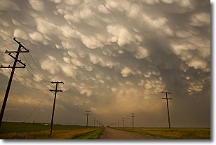
Weather Topic: What are Mammatus Clouds?
Home - Education - Cloud Types - Mammatus Clouds
 Next Topic: Nimbostratus Clouds
A mammatus cloud is a cloud with a unique feature which resembles
a web of pouches hanging along the base of the cloud.
In the United States, mammatus clouds tend to form in the warmer months, commonly
in the Midwest and eastern regions.
While they usually form at the bottom of a cumulonimbis cloud, they can also form
under altostratus, altocumulus, stratocumulus, and cirrus clouds. Mammatus clouds
warn that severe weather is close.
Next Topic: Nimbostratus Clouds
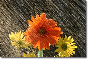
Weather Topic: What is Precipitation?
Home - Education - Precipitation - Precipitation
 Next Topic: Rain
Precipitation can refer to many different forms of water that
may fall from clouds. Precipitation occurs after a cloud has become saturated to
the point where its water particles are more dense than the air below the cloud.
In most cases, precipitation will reach the ground, but it is not uncommon for
precipitation to evaporate before it reaches the earth's surface.
When precipitation evaporates before it contacts the ground it is called Virga.
Graupel, hail, sleet, rain, drizzle, and snow are forms of precipitation, but fog
and mist are not considered precipitation because the water vapor which
constitutes them isn't dense enough to fall to the ground.
Next Topic: Rain
Current conditions powered by WeatherAPI.com


