Weather Alert in Wisconsin
Winter Storm Watch issued March 31 at 2:50PM CDT until April 2 at 7:00PM CDT by NWS Twin Cities/Chanhassen MN
AREAS AFFECTED: Polk; Barron; Rusk; St. Croix; Pierce; Dunn; Pepin; Chippewa; Eau Claire
DESCRIPTION: ...MESSY SPRING SYSTEM TO BRING RAIN, FREEZING RAIN, SLEET, AND SNOW TO PORTIONS OF MINNESOTA AND WISCONSIN WEDNESDAY THROUGH THURSDAY... .A strong system is expected to bring a variety of precipitation types to the region Wednesday through Thursday. While there is still some uncertainty in the exact track of the low, a mix of snow and sleet is expected for much of central and western Minnesota. Further to the south and east, sleet and freezing rain will be the primary precipitation type. Some shifts in the track are still anticipated, which will influence the total accumulations of snow, sleet, freezing rain, and rain. * WHAT...Heavy mixed precipitation possible. Total snow accumulations up to two inches, sleet accumulations around 1 inch, and ice accumulations up to two tenths of an inch possible. * WHERE...Barron, Polk, Rusk, Chippewa, Dunn, Eau Claire, Pepin, Pierce, and St. Croix Counties. * WHEN...From Wednesday evening through Thursday evening. * IMPACTS...Plan on slippery road conditions. The hazardous conditions could impact the Wednesday evening and Thursday morning commutes.
INSTRUCTION: Monitor the latest forecasts for updates on this situation.
Want more detail? Get the Complete 7 Day and Night Detailed Forecast!
Current U.S. National Radar--Current
The Current National Weather Radar is shown below with a UTC Time (subtract 5 hours from UTC to get Eastern Time).

National Weather Forecast--Current
The Current National Weather Forecast and National Weather Map are shown below.

National Weather Forecast for Tomorrow
Tomorrow National Weather Forecast and Tomorrow National Weather Map are show below.

North America Water Vapor (Moisture)
This map shows recent moisture content over North America. Bright and colored areas show high moisture (ie, clouds); brown indicates very little moisture present; black indicates no moisture.

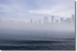
Weather Topic: What is Fog?
Home - Education - Cloud Types - Fog
 Next Topic: Fractus Clouds
Fog is technically a type of stratus cloud, which lies along the
ground and obscures visibility.
It is usually created when humidity in the air condenses into tiny water droplets.
Because of this, some places are more prone to foggy weather, such as regions
close to a body of water.
Fog is similar to mist; both are the appearance of water droplets suspended in
the air, but fog is the term applied to the condition when visibility is less than 1 km.
Next Topic: Fractus Clouds
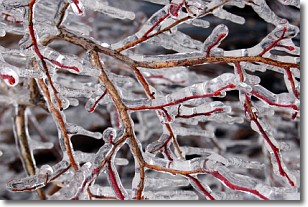
Weather Topic: What is Freezing Rain?
Home - Education - Precipitation - Freezing Rain
 Next Topic: Graupel
Freezing rain is a condition where precipitation which has fallen in the form of
water droplets reaches temperatures which are below freezing and freezes upon
coming into contact
with surface objects. The result of this precipitation is a glaze of ice which
can be damaging to plants and man-made structures. A severe onset of freezing
rain which results in a very thick glaze of ice is known as an ice storm.
Next Topic: Graupel
Current conditions powered by WeatherAPI.com


