Weather Alert in Louisiana
Flood Advisory issued June 29 at 11:38AM CDT until July 6 at 7:00PM CDT by NWS Jackson MS
AREAS AFFECTED: Madison, LA; Tensas, LA; Claiborne, MS; Jefferson, MS; Warren, MS
DESCRIPTION: ...The Flood Advisory is extended for the following rivers in Mississippi...Arkansas...Louisiana... Mississippi River Near Greenville affecting Issaquena, East Carroll, Chicot and Washington Counties. Mississippi River At Natchez affecting Wilkinson, Adams and Concordia Counties. Mississippi River At Vicksburg affecting Jefferson, Warren, Tensas, Claiborne and Madison Counties. * WHAT...Flooding caused by excessive rainfall continues. * WHERE...Mississippi River at Vicksburg. * WHEN...Until Sunday, July 06. * IMPACTS...At 38.8 feet, The Vicksburg FloodWall Gate at Crawford street is closed. * ADDITIONAL DETAILS... - At 11:00 AM CDT Sunday the stage was 39.1 feet. - Forecast...The river is expected to fall to 28.5 feet Sunday, July 27. - Action stage is 35.0 feet. - Flood stage is 43.0 feet. - http://www.weather.gov/safety/flood
INSTRUCTION: If you encounter a flooded roadway, turn around and find an alternative route. Additional information is available at www.water.noaa.gov/wfo/jan The next statement will be issued Monday morning at 1100 AM CDT.
Want more detail? Get the Complete 7 Day and Night Detailed Forecast!
Current U.S. National Radar--Current
The Current National Weather Radar is shown below with a UTC Time (subtract 5 hours from UTC to get Eastern Time).

National Weather Forecast--Current
The Current National Weather Forecast and National Weather Map are shown below.

National Weather Forecast for Tomorrow
Tomorrow National Weather Forecast and Tomorrow National Weather Map are show below.

North America Water Vapor (Moisture)
This map shows recent moisture content over North America. Bright and colored areas show high moisture (ie, clouds); brown indicates very little moisture present; black indicates no moisture.

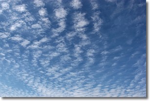
Weather Topic: What are Cirrocumulus Clouds?
Home - Education - Cloud Types - Cirrocumulus Clouds
 Next Topic: Cirrostratus Clouds
Cirrocumulus clouds form at high altitudes (usually around 5 km)
and have distinguishing characteristics displayed in a fine layer of
small cloud patches. These small cloud patches are sometimes referred to as
"cloudlets" in relation to the whole cloud formation.
Cirrocumulus clouds are formed from ice crystals and water droplets. Often, the
water droplets in the cloud freeze into ice crystals and the cloud becomes a
cirrostratus cloud. Because of this common occurrence, cirrocumulus cloud
formations generally pass rapidly.
Next Topic: Cirrostratus Clouds
Weather Topic: What are Cirrus Clouds?
Home - Education - Cloud Types - Cirrus Clouds
 Next Topic: Condensation
Cirrus clouds are high-level clouds that occur above 20,000 feet
and are composed mainly of ice crystals.
They are thin and wispy in appearance.
What do they indicate?
They are often the first sign of an approaching storm.
Next Topic: Condensation
Current conditions powered by WeatherAPI.com


