Weather Alert in Vermont
Air Quality Alert issued August 2 at 4:58PM EDT by NWS Albany NY
AREAS AFFECTED: Bennington; Western Windham; Eastern Windham
DESCRIPTION: The Vermont Agency of Natural Resources has issued an Air Quality Action Alert for fine particulates from wildfire smoke from midnight tonight to midnight EDT Sunday night. The Air Quality Index (AQI) is expected to approach or exceed the Code Orange or Unhealthy for sensitive groups category in southern Vermont. Concentrations are expected to be highest in the afternoon hours on Sunday. Who needs to be concerned? For Unhealthy air quality the entire population. For USG air quality - Sensitive groups include: people with heart or lung disease, older adults, children, and teenagers. What should you do? For Unhealthy air quality everyone should reduce prolonged or strenuous outdoor activities. For USG air quality - Sensitive groups should reduce prolonged or heavy exertion. It's OK to be active outside, but take more breaks and do less intense activities. Watch for symptoms such as coughing or shortness of breath. People with asthma should follow their asthma action plans and keep quick-relief medicine handy. If you have heart disease: Symptoms such as palpitations, shortness of breath, or unusual fatigue may indicate a serious problem. If you have any of these, contact your healthcare provider. For additional information, please visit the Vermont Agency of Natural Resources website at https://dec.vermont.gov/air-quality/local-air- quality-forecasts.
INSTRUCTION: N/A
Want more detail? Get the Complete 7 Day and Night Detailed Forecast!
Current U.S. National Radar--Current
The Current National Weather Radar is shown below with a UTC Time (subtract 5 hours from UTC to get Eastern Time).

National Weather Forecast--Current
The Current National Weather Forecast and National Weather Map are shown below.

National Weather Forecast for Tomorrow
Tomorrow National Weather Forecast and Tomorrow National Weather Map are show below.

North America Water Vapor (Moisture)
This map shows recent moisture content over North America. Bright and colored areas show high moisture (ie, clouds); brown indicates very little moisture present; black indicates no moisture.

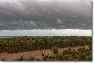
Weather Topic: What are Shelf Clouds?
Home - Education - Cloud Types - Shelf Clouds
 Next Topic: Sleet
A shelf cloud is similar to a wall cloud, but forms at the front
of a storm cloud, instead of at the rear, where wall clouds form.
A shelf cloud is caused by a series of events set into motion by the advancing
storm; first, cool air settles along the ground where precipitation has just fallen.
As the cool air is brought in, the warmer air is displaced, and rises above it,
because it is less dense. When the warmer air reaches the bottom of the storm cloud,
it begins to cool again, and the resulting condensation is a visible shelf cloud.
Next Topic: Sleet
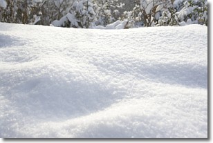
Weather Topic: What is Snow?
Home - Education - Precipitation - Snow
 Next Topic: Stratocumulus Clouds
Snow is precipitation taking the form of ice crystals. Each ice crystal, or snowflake,
has unique characteristics, but all of them grow in a hexagonal structure.
Snowfall can last for sustained periods of time and result in significant buildup
of snow on the ground.
On the earth's surface, snow starts out light and powdery, but as it begins to melt
it tends to become more granular, producing small bits of ice which have the consistency of
sand. After several cycles of melting and freezing, snow can become very dense
and ice-like, commonly known as snow pack.
Next Topic: Stratocumulus Clouds
Current conditions powered by WeatherAPI.com


