Weather Alert in Minnesota
Winter Weather Advisory issued April 1 at 1:13AM CDT until April 3 at 7:00AM CDT by NWS Duluth MN
AREAS AFFECTED: Carlton/South St. Louis; Pine; Douglas
DESCRIPTION: * WHAT...Mixed precipitation expected. Total snow and sleet accumulations between 3 and 5 inches except between 4 and 6 inches for the higher terrain of the North Shore and ice accumulations around one tenth of an inch. Winds gusting as high as 35 mph. * WHERE...In Minnesota, Pine and Carlton and South St. Louis Counties. In Wisconsin, Douglas County. This includes the Tribal Lands of the Fond du Lac Band and the Mille Lacs Band, Hinckley and, Lena Lake areas. * WHEN...From 1 AM Thursday to 7 AM CDT Friday. * IMPACTS...Travel could be very difficult. The hazardous conditions could impact the Thursday morning and evening commutes. * ADDITIONAL DETAILS...Worst conditions will be closer to Lake Superior as strong winds off of the Lake will lead to higher snow totals and greater reductions in visibilities. The majority of the snowfall is expected to fall during the daytime hours. With the high sun angle and temperatures hovering just above freezing, snowfall will have a difficult time accumulating on warm surfaces leading to a slushy mess.
INSTRUCTION: Slow down and use caution while traveling. In Minnesota, call 511 or visit www.511mn.org for Minnesota road information. In Wisconsin, call 511 or visit www.511wi.gov for Wisconsin road information.
Want more detail? Get the Complete 7 Day and Night Detailed Forecast!
Current U.S. National Radar--Current
The Current National Weather Radar is shown below with a UTC Time (subtract 5 hours from UTC to get Eastern Time).

National Weather Forecast--Current
The Current National Weather Forecast and National Weather Map are shown below.

National Weather Forecast for Tomorrow
Tomorrow National Weather Forecast and Tomorrow National Weather Map are show below.

North America Water Vapor (Moisture)
This map shows recent moisture content over North America. Bright and colored areas show high moisture (ie, clouds); brown indicates very little moisture present; black indicates no moisture.

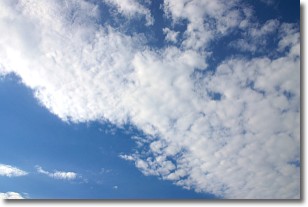
Weather Topic: What are Stratus Clouds?
Home - Education - Cloud Types - Stratus Clouds
 Next Topic: Wall Clouds
Stratus clouds are similar to altostratus clouds, but form at a
lower altitude and are identified by their fog-like appearance, lacking the
distinguishing features of most clouds.
Stratus clouds are wider than most clouds, and their base has a smooth, uniform
look which is lighter in color than a nimbostratus cloud.
The presence of a stratus cloud indicates the possibility of minor precipitation,
such as drizzle, but heavier precipitation does not typically arrive in the form
of a stratus cloud.
Next Topic: Wall Clouds
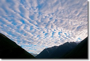
Weather Topic: What are Altocumulus Clouds?
Home - Education - Cloud Types - Altocumulus Clouds
 Next Topic: Altostratus Clouds
Similar to cirrocumulus clouds, altocumulus clouds are
characterized by cloud patches. They are distinguished by larger cloudlets
than cirrocumulus clouds but are still smaller than stratocumulus clouds.
Altocumulus clouds most commonly form in middle altitudes (between 2 and 5 km)
and may resemble, at times, the shape of a flying saucer.
These uncommon formations, called altocumulus lenticularis, are created by uplift
in the atmosphere and are most often seen in close proximity to mountains.
Next Topic: Altostratus Clouds
Current conditions powered by WeatherAPI.com


