Weather Alert in Minnesota
Winter Storm Warning issued April 1 at 1:13AM CDT until April 3 at 7:00AM CDT by NWS Duluth MN
AREAS AFFECTED: Southern Lake/North Shore; Southern Cook/North Shore
DESCRIPTION: * WHAT...Heavy mixed precipitation expected. Total snow and sleet accumulations between 7 and 10 inches and ice accumulations around a light glaze. Winds gusting as high as 45 mph. * WHERE...Southern Cook and Southern Lake Counties. This includes the Tribal Lands of the Grand Portage Reservation. * WHEN...From 1 AM Thursday to 7 AM CDT Friday. * IMPACTS...Travel could be very difficult. The hazardous conditions could impact the Thursday morning and evening commutes. Gusty winds could bring down tree branches. * ADDITIONAL DETAILS...The majority of the snowfall is expected to fall during the daytime hours. With the high sun angle and temperatures hovering just above freezing, snowfall will have a difficult time accumulating on warm surfaces leading to a slushy mess.
INSTRUCTION: If you must travel, keep an extra flashlight, food, and water in your vehicle in case of an emergency. Call 511 or visit www.511mn.org for Minnesota road information.
Want more detail? Get the Complete 7 Day and Night Detailed Forecast!
Current U.S. National Radar--Current
The Current National Weather Radar is shown below with a UTC Time (subtract 5 hours from UTC to get Eastern Time).

National Weather Forecast--Current
The Current National Weather Forecast and National Weather Map are shown below.

National Weather Forecast for Tomorrow
Tomorrow National Weather Forecast and Tomorrow National Weather Map are show below.

North America Water Vapor (Moisture)
This map shows recent moisture content over North America. Bright and colored areas show high moisture (ie, clouds); brown indicates very little moisture present; black indicates no moisture.

Weather Topic: What is Freezing Rain?
Home - Education - Precipitation - Freezing Rain
 Next Topic: Graupel
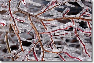
Freezing rain is a condition where precipitation which has fallen in the form of
water droplets reaches temperatures which are below freezing and freezes upon
coming into contact
with surface objects. The result of this precipitation is a glaze of ice which
can be damaging to plants and man-made structures. A severe onset of freezing
rain which results in a very thick glaze of ice is known as an ice storm.
Next Topic: Graupel
Weather Topic: What is Hail?
Home - Education - Precipitation - Hail
 Next Topic: Hole Punch Clouds
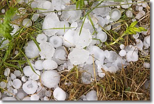
Hail is a form of precipitation which is recognized by large solid balls or
clumps of ice. Hail is created by thunderstorm clouds with strong updrafts of wind.
As the hailstones remain in the updraft, ice is deposited onto them until their
weight becomes heavy enough for them to fall to the earth's surface.
Hail storms can cause significant damage to crops, aircrafts, and man-made structures,
despite the fact that the duration is usually less than ten minutes.
Next Topic: Hole Punch Clouds
Current conditions powered by WeatherAPI.com


