Weather Alert in Georgia
Flood Watch issued August 2 at 3:12PM EDT until August 3 at 4:00AM EDT by NWS Tallahassee FL
AREAS AFFECTED: Quitman; Clay; Randolph; Calhoun; Terrell; Dougherty; Lee; Worth; Turner; Tift; Ben Hill; Irwin; Early; Miller; Baker; Mitchell; Colquitt; Cook; Berrien; Decatur; Grady; Thomas; Brooks; Lowndes; Lanier
DESCRIPTION: * WHAT...Flash flooding caused by excessive rainfall is possible across Southwest and South Central Georgia. * WHERE...For the following counties in South Central Georgia, Ben Hill, Berrien, Brooks, Colquitt, Cook, Irwin, Lanier, Lowndes, Thomas, Tift, Turner and Worth. In southwest Georgia, Baker, Calhoun, Clay, Decatur, Dougherty, Early, Grady, Lee, Miller, Mitchell, Quitman, Randolph and Terrell. * WHEN...Through 4 AM EDT Sunday Morning. * IMPACTS...Excessive runoff may result in flash flooding of roadways as well as greater impacts in urban areas where flood-prone neighborhoods could be especially vulnerable to rising water. Small creeks may also rise rapidly, leading to flooding. * ADDITIONAL DETAILS... - A very moist airmass is in place across the region and numerous showers and thunderstorms are expected to develop later this afternoon and evening across South Georgia. Due to the slow motion of these storms, some areas could see rainfall totals of 3 to 5 inches with isolated maximum amounts of 7 inches through tonight. - http://www.weather.gov/safety/flood
INSTRUCTION: You should monitor later forecasts and be alert for possible Flash Flood Warnings. Those living in areas prone to flooding should be prepared to take action should flash flooding develop.
Want more detail? Get the Complete 7 Day and Night Detailed Forecast!
Current U.S. National Radar--Current
The Current National Weather Radar is shown below with a UTC Time (subtract 5 hours from UTC to get Eastern Time).

National Weather Forecast--Current
The Current National Weather Forecast and National Weather Map are shown below.

National Weather Forecast for Tomorrow
Tomorrow National Weather Forecast and Tomorrow National Weather Map are show below.

North America Water Vapor (Moisture)
This map shows recent moisture content over North America. Bright and colored areas show high moisture (ie, clouds); brown indicates very little moisture present; black indicates no moisture.

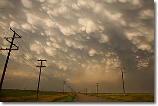
Weather Topic: What are Mammatus Clouds?
Home - Education - Cloud Types - Mammatus Clouds
 Next Topic: Nimbostratus Clouds
A mammatus cloud is a cloud with a unique feature which resembles
a web of pouches hanging along the base of the cloud.
In the United States, mammatus clouds tend to form in the warmer months, commonly
in the Midwest and eastern regions.
While they usually form at the bottom of a cumulonimbis cloud, they can also form
under altostratus, altocumulus, stratocumulus, and cirrus clouds. Mammatus clouds
warn that severe weather is close.
Next Topic: Nimbostratus Clouds
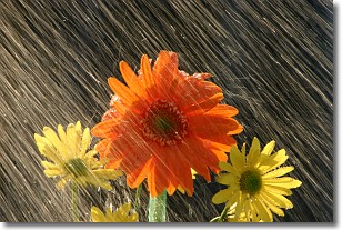
Weather Topic: What is Precipitation?
Home - Education - Precipitation - Precipitation
 Next Topic: Rain
Precipitation can refer to many different forms of water that
may fall from clouds. Precipitation occurs after a cloud has become saturated to
the point where its water particles are more dense than the air below the cloud.
In most cases, precipitation will reach the ground, but it is not uncommon for
precipitation to evaporate before it reaches the earth's surface.
When precipitation evaporates before it contacts the ground it is called Virga.
Graupel, hail, sleet, rain, drizzle, and snow are forms of precipitation, but fog
and mist are not considered precipitation because the water vapor which
constitutes them isn't dense enough to fall to the ground.
Next Topic: Rain
Current conditions powered by WeatherAPI.com


